Of mountain names and hay

Letter from Slim Wolfe

Geography – September 2008 – Colorado Central Magazine

Editors:

Talk about making a mountain out of a molehill….

Plainly, the mountain doesn’t give a hoot what you call it or who gets the credit, nor do dead soldiers seem likely to take offense, however, the backers of this presumptuous KIAMIA notion have got some more free publicity out of the squabble in your letters column. Seems to me they ought to call off the whole affair for lack of interest and leave the mountain in peace.

Read more

Developments on KIA/MIA

Letter from Bruce Salisbury

Geography – September 2008 – Colorado Central Magazine

Editors:

On the 6th of August a small group of us gathered at Mount KIA/MIA. Royce and Barry Raven, and Barry’s wife Raman came there to climb the mountain for all the KIA/MIA, and to determine a best route and to take photos of the event.

Read more

From Kit Carson to Tranquility?

Brief by Central Staff

Geography – August 2008 – Colorado Central Magazine

According to one of our favorite books of mountain lore (A Climbing Guide to Colorado’s Fourteeners, by Walter R. Borneman and Lyndon J. Lampert), there has always been some confusion about names for the peaks in the Sangre de Cristo range above the town of Crestone.

There are Crestone Peak (14,294) and Crestone Needle (14,197). They were not climbed until 1916, which makes them the last 14ers in Colorado to be climbed. Nearby is Kit Carson Peak (14,165).

Read more

Mt. KIA/MIS is on the map

Brief by Central Staff

Geography – November 2007 – Colorado Central Magazine

A formerly nameless mountain in Saguache County is now Mt. KIA/MIA to honor American military personnel who were either “Killed In Action” (KIA) or “Missing In Action” (MIA). The peak is 11,293 feet high, and it rises along the divide between Silver and Starvation creeks in the Marshall Pass area.

Read more

The most remote place in the 48 states

Brief by Allen Best

Geography – June 2007 – Colorado Central Magazine

Want to get away from it all? If remoteness is defined by the absence of roads, then Hinsdale County, located in Colorado’s San Juan Mountains, is the most remote place in the lower 48 states.

Read more

A mountain to honor warriors

Brief by Central Staff

Geography – March 2007 – Colorado Central Magazine

There’s a proposal afoot to christen a heretofore nameless peak in Sagauche County; the suggested name is Mt. Kiamia. A more informative way to spell it would be Mt. KIA/MIA, as the idea is to honor American soldiers who were either Killed In Action or Missing In Action.

Read more

A growth-control measure

Letter from Laird Campbell

Geography – January 2007 – Colorado Central Magazine

Editors:

The Colorado map shows that Chaffee County has more 14,000-foot mountains than any other county in Colorado and probably more than anywhere else in the United States. From north to south they are: La Plata Peak, Huron Peak, Mt. Belford, Mt. Oxford, Missouri Mt., Mt. Harvard, Mt. Columbia, Mt. Yale, Mt. Princeton, Mt. Antero, Tabeguache Mt. and Mt. Shavano.

Read more

Shameless self-promotion

Letter from Harvey N. Gardiner

Geography – December 2006 – Colorado Central Magazine

Editors:

I always find Colorado Central interesting reading. You may be surprised at the obscure things this reader, at least, notices, but which also give me the opportunity for shameless self-promotion.

Read more

Where’s the High Desert?

Brief by Central Staff

Geography – June 2006 – Colorado Central Magazine

We sometimes explain Colorado Central as “the monthly magazine for America’s highest deserts,” but a recent excursion got us to wondering about high deserts. That’s because we visited the Museum of the High Desert just outside Bend, Ore. There, the “high desert” is defined as a combination of the Columbia Plateau and the Great Basin, and does not extend to Colorado.

Read more

Sewanee: An unrecognized Collegiate Peak

Article by Merritt R. Blakeslee

Geography -April 2006 -Colorado Central Magazine

IN 1949 TWO GEOLOGISTS in the Denver office of the U.S. Geological Survey were assigned the task of updating the geological description of that portion of Gunnison and Chaffee counties covered by the USGS Garfield Colorado 15-minute quadrangle. The geology of this area had been cursorily surveyed by the Hayden Survey1 and was the subject of a detailed study in 1913;2 and the two geologists were charged with bringing this previous work up to date.

Read more

Veta v. La Veta

Letter from Virginia McConnell Simmons

Geography – April 2006 – Colorado Central Magazine

Editors:

Here is a small stick to throw onto the flickering flames about whether the original, narrow- gauge D&RG route crossed La Veta Pass or Veta Pass, and whether the later standard- gauge route crossed Veta Pass or La Veta Pass. Today I think we should defer to USGS maps and accept the northern (narrow- gauge) pass as La Veta and the southern pass as Veta.

Read more

Where’s the Front Range?

Letter from Roger Kirkpatrick

Geography – January 2006 – Colorado Central Magazine

Hi Ed,

This is sort of a homeland question, did you move to Salida from the Front Range, as you state on page 45, or was it really the Great Plains?

I suspect you grew up on the Great Plains and that you, like most of Colorado’s population, used “Front Range”, even if incorrect, because it sounds better than Great Plains.

Read more

How was Mt. White named?

Letter from Virginia McConnell Simmons

Geography – August 2005 – Colorado Central Magazine

Dear Ed and Martha,

Since your publication of my article about the names of Mts. Shavano, Tabeguache, and Antero in Colorado Central (June 2005), I have been attempting to find an explanation for the name of Mt. White, an anomaly amongst those Indian peaks.

Read more

There’s another Pike’s Peak

Brief by Central Staff

Geography – August 2005 – Colorado Central Magazine

Next year marks the bicentennial of Lt. Zebulon Montgomery Pike’s 1806-07 expedition to Colorado, which included a Christmas camp near Salida and his capture by Spanish soldiers in the San Luis Valley.

This bicentennial won’t get nearly the attention that the Lewis and Clark “Voyage of Discovery” is getting now, although news is trickling in about some likely events in 2006, including a possible visit by a Pike impersonator.

Read more

Naming the Indian group of the Sawatch Range

Article by Virginia McConnell Simmons

Geography – June 2005 – Colorado Central Magazine

THE SAWATCH RANGE on the west side of Chaffee County is a visual knock-out, and the names of some of its peaks offer a reminder of the area’s past history. Among alien labels like Princeton and Harvard, a handful of mountains in the range bear names that honor the Ute Indians, who occupied this region for roughly six centuries before white folks moved in.

Read more

Pine returns to being Pine Grove

Brief by Central Staff

Geography – February 2005 – Colorado Central Magazine

A mountain town on the old Denver, South Park & Pacific Railroad line has regained its old name.

The spot, on the west edge of Jefferson County, has for years been known as Pine. Its not on any major route now, but logically enough, you get on the road to Pine by turning southeast from U.S. 285 at Pine Junction.

Read more

The problem with those sacred places

Essay by Ed Quillen

Geography – December 2004 – Colorado Central Magazine

THE ANNUAL Headwaters Conference at Western State College in Gunnison did what it was supposed to do this time around — make me think about things I don’t normally think about. I’m pretty good at getting bogged down in daily minutia, from firewood splitting to computer maintenance, and thus seldom step back to look at the bigger picture. When it comes to “not seeing the forest for the trees,” I suppose I prefer to look at the individual trees and rate their suitability as cordwood, rather than ponder biodiversity, ecosystems, endangered species, global warming, or other major matters.

Read more

And soon, Athrop Heights?

Brief by Central Staff

Geography – August 2004 – Colorado Central Magazin

On a typical month, we receive two or three “Change of Address” notifications from the U.S. Postal Service. (Each one costs us 70¢, so we encourage our subscribers to tell us their new address before they move.)

Read more

We have the highest mountains, but not the highest lake

Brief by Allen Best

Geography – February 2004 – Colorado Central Magazine

Central Colorado can boast of the highest mountains in Colorado — Elbert, Massive, and Harvard are 1, 2, and 3 — but the highest lake is apparently in Summit County.

It might even be the highest lake in the United States, according to Carl Drews of Breckenridge. Nowhere can he find evidence of a lake at a higher elevation than one at 13,420 feet near Breckenridge that he proposes to call Pacific Tarn.

Read more

Locating Mancos

Letter from S. Roger Kirkpatrick

Geography – January 2004 – Colorado Central Magazine

Editors:

There will be nit pickers complaining about Denver Post writers that don’t know how far it is from Cortez to Mancos [p. 7, December edition], but you can just tell them it was an omission as in:

Read more

Blaurock and Ervin now official names

Brief by Allen Best

Geography – December 2003 – Colorado Central Magazine

It’s now official. The U.S. Board of Geographic Names has named two hitherto unnamed summits near Granite after Carl Blaurock and Bill Ervin, who were the first and second mountaineers to bag all the peaks then considered fourteeners.

Read more

Plutocracy encounters folk wisdom in Aspen

Essay by Tim Willoughby

Geography – November 2003 – Colorado Central Magazine

THE MEDIA RELISHED reporting Ken Lay’s sale of two homes in Aspen. The former Enron exec, who became the poster boy of corporate malfeasance, was President Bush’s major source of campaign funds in both his Texas governor race and his 2000 presidential campaign. But Lay had to liquidate quickly to build up his defense fund.

Read more

Truly bad directions

Brief by Central Staff

Geography – October 2003 – Colorado Central Magazine

If you ended up giving directions to lost drivers trying to find the Colorado Trail, blame the Rocky Mountain News.

The Aug. 16 edition of the Denver newspaper had a long article about the Colorado Trail, a 470-mile path between Durango and the southwest metro suburbs. The article also had a suggestion for a day hike along the trail in the Leadville area.

Read more

One way to remove Lake Powell?

Brief by Ed Quillen

Geography – September 2003 – Colorado Central Magazine

Back when I was editor of the Summit County Journal in Breckenridge (1977-78), I ran into a problem with nomenclature concerning that county’s largest body of water. The chamber of commerce liked to call it “Lake Dillon,” but I preferred “Dillon Reservoir.”

In my view, lake should be reserved for natural bodies of water, and Dillon had been built by the Denver Water Board to store Western Slope water to be delivered by the Roberts Tunnel that emerges near Grant on U.S. 285.

Read more

Things you might not have known about Dotsero

Brief by Central Staff

Geography – August 2003 – Colorado Central Magazine

Several wildfires were burning as we went to press, including one near a rather obscure spot named “Dotsero.” That’s also the name of a jazz band which usually plays in Salida every fall, but there’s more to Dotsero’s lore.

Read more

Where is Central Colorado?

Letter from Roger Henn

Geography – July 2003 – Colorado Central Magazine

Dear Quillens:

Nine years ago you may have set out to redefine “Central Colorado.” But the lines you seem to have established are weird.

You include Alamosa, etc., towns which are further south than Montrose, which you do not include. You include Creede but not Lake City (further North and closer to Central) or Silverton.

Read more

Kat Carson gets a new name: Columbia Point

Brief by Central Staff

Geography – July 2003 – Colorado Central Magazine

A peak in the Sangre de Cristo Range near Crestone has a new name: Columbia Point, to honor the space shuttle that crashed on Feb. 1, killing all seven astronauts aboard.

Columbia Point, 13,960 feet, is on the north side of 14,165-foot Kit Carson Peak. It had no formal name before, but was sometimes called “Kat Carson” or “East Summit.”

Read more

A question of distance

Brief by Central Staff

Geography – May 2002 – Colorado Central Magazine

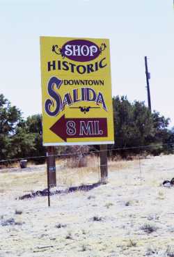
How far is it to Salida from the junction of U.S. 285 and Colo. 291? The most prominent sign, the Shop Historic Downtown Salida billboard, says it’s 8 miles.

Read more

Headwaters Hill is a special triple divide

Letter from Dale Sanderson

Geography – March 2002 – Colorado Central Magazine

Ed:

A few comments regarding Ken Stitzel’s letter (“More Triple Divides”) in the February issue:

He is correct in his identification of the three “corners” of the Closed Basin. As you and I discussed during one of the naming hikes, if one considers the Continental Divide to be a single line separating Atlantic from Pacific, then that line technically does not exist between Headwaters Hill and “Point 13,628.”

Read more

And if you want a map with Kokomo on it

Brief by Central Staff

Geography – March 2002 – Colorado Central Magazine

Curious about the Colorado of 1894? Then the U.S. Geological Survey has just republished a map that should answer a few questions.

The map, originally developed by the Caxton Co. and published by James McConnell School Supplies of Denver, had languished in the archives of the Library of Congress for years before it was discovered last summer by Peggy Ellis, who was on vacation in Washington, D.C., from her regular work at the U.S. Geological Survey in Lakewood.

Read more

Kokomo: Smaller than a small town?

Brief by Central Staff

Geography – March 2002 – Colorado Central Magazine

If you’re somewhat into politics, you’ve doubtless heard of Karl Rove, chief political advisor to President George Walker Bush.

Rove was born in Denver (on Christmas Day, 1950), and spent some of his boyhood in Colorado. His father was a geologist and the family moved often; after stints in Utah and Nevada, Rove moved to Texas in 1977, and operated there as a political consultant until he moved to Washington with the Bush administration.

Read more

More triple divides

Letter from Ken Stitzel

Geography – February 2002 – Colorado Central Magazine

Editors:

That was an interesting article about the triple divide at Headwaters Hill, “A Letter from the Editors: Playing the Name Game (and enjoying it)” in the September issue. However, if you are extolling the Closed Basin as part of the triple divide, there would seem to be three triple divides defining the corners of the basin.

Read more

14,134-foot South Elbert will remain officially nameless

Brief by Central Staff

Geography – January 2002 – Colorado Central Magazine

The 14,134-foot mountain informally known as South Elbert won’t get a formal name from the U.S. Board on Geographic Names.

The board made that decision at its Sept. 5 meeting when it declined to approve either of two proposals for a new name.

One was to call it Mount Duke — presumably for the university in North Carolina, although we don’t know for sure, since this was the first we’d heard of this.

Read more

History offers many names for the Rio Grande

Letter from Virgina M. Simmons

Geography – November 2001 – Colorado Central Magazine

Editors:

On my bookshelves, the best summary of names for the Rio Grande is found in Carroll L. Riley’s Rio del Norte: People of the Upper Rio Grande from Earliest Times to the Pueblo Revolt (University of Utah Press, 1995). Riley begins with the names used by Pueblo Indians in New Mexico when the Spaniards arrived. Puebloan descriptive names testify to the fact that this was the largest stream they knew.

Read more

Inches of acres, and some minor triple divides

Letter from Roger Williams

Geography – October 2001 – Colorado Central Magazine

Editors:

I noticed with amusement that the ad from the Wall Street Journal, “Colorado: An Enviable Position” about “Southfork” that was on page 11 [of the September edition of Colorado Central], and says their sites “are protected by almost 2 mm acres” of National Forest land. This is 2 millimeters or about 1/12 of an inch. (I think they meant million). Of course, an inch of acres doesn’t mean anything.

Read more

¡No es Brazo!

Brief by Central Staff

Geography – October 2001 – Colorado Central Magazine

In a discussion of place names in the September edition, our bifocal-wearing publisher misread Rio Bravo on a map as Rio Brazo.

Read more

Playing the Name Game (and enjoying it)

Essay by Ed Quillen

Geography – September 2001 – Colorado Central Magazine

PLACE NAMES have always fascinated me. I admire the exuberance of “Oh Be Joyful Creek” and the rough honesty of “Son of a Bitch Hill” (a/k/a Cerro Summit between Gunnison and Montrose). “Fairplay” and “Tarryall” are charming names for towns, and it’s refreshing to know that we Salidans have been mispronouncing our town’s name since it was christened in 1880.

Read more

Developments in greater metropolitan Cotopaxi

Letter from Charlie Green

Geography – August 2001 – Colorado Central Magazine

Developments in greater metropolitan Cotopaxi

Editors:

OK, Ed. I was pretty ticked to find that you made Cotopaxi the east edge of your Central Colorado diamond. I had always visualized CC as an approximate rectangle: Parkdale; Trinidad; SW corner of the San Luis valley; and Gunnison. I will adjust my boundaries to be more limited. But squinting closely, I could see Texas Creek on the cover of the phone directory which was [almost] geographically congruent with your Salidian (or whatever) oriented vision. On the other hand, this is a case where being in “greater metropolitan Cotopaxi” makes me Central.

Read more

No Longer Nameless

Brief by Central Staff

Geography – August 2001 – Colorado Central Magazine

As mountains go, especially in our part of the world, this little rise in Saguache County doesn’t stand out. At 11,861 feet, it doesn’t even reach timberline, and there’s nothing memorable about its shape.

Read more

A mountain called ‘Ed’

Essay by Lou Bendrick

Geography – July 2001 – Colorado Central Magazine

THE THING I DON’T LIKE about house guests is the fact that they’re nosy and ask meddlesome questions. Questions about geography, for instance.

“What’s that mountain?,” they’ll ask, pointing to the snow-capped behemoth outside my kitchen window.

“That,” I’ll say stammering, wracking my brain, “is…Big Pointy.”

Read more

Is Salida secretly searching for a new slogan?

Brief by Central Staff

Geography – January 2001 – Colorado Central Magazine

While cleaning the other day, we ran across an old Salida phone book, which of course ended up where the new one should be when it was time to look up a number, whereupon we discovered that the “Salida Chamber of Commerce” used to be listed as the “Heart of the Rockies Chamber of Commerce.”

Read more