
Brief by Central Staff
Geography – August 2001 – Colorado Central Magazine
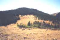
As mountains go, especially in our part of the world, this little rise in Saguache County doesn’t stand out. At 11,861 feet, it doesn’t even reach timberline, and there’s nothing memorable about its shape.
![[Headwaters Hill]](https://coloradocentralmagazine.com/wp-content/uploads/2009/11/00900041.JPG "[Headwaters Hill]")
[Headwaters Hill]
But it does have a distinctive drainage pattern, and on that account, it now has an official name: Headwaters Hill, approved on July 12 by the U.S. Board on Geographic Names.
According to Dale Sanderson, a Denver cartographer who worked for the name, Headwaters Hill is one of only five “triple divides” in the United States — places where the water runs off into three different eventual destinations.
The three drainages of Headwaters Hill are Millswitch Creek (to the Gunnison and Colorado rivers, and in theory the Pacific Ocean), Silver Creek (to the Arkansas and Mississippi rivers, and the Atlantic, and Middle Creek (to the Closed Basin of the San Luis Valley, and to the Rio Grande with some help from the U.S. Bureau of Reclamation).
Headwaters Hill is about 4½ miles south of the summit of Marshall Pass along the Continental Divide and Colorado trails.
The other main mover on the naming was George Sibley of Gunnison (also a columnist for this magazine), who worked to obtain endorsements from three county governments, the state government, and various ranger districts.
In recent years, Sibley has led a hike to the summit every fall, in late September or early October. In the past, it’s been called a “naming quest,” but this year it promises to be a celebration: Perhaps a christening party with champagne erupting into three drainages.
We hope to offer some details next month about the Headwaters Hill Hike of 2001.