

By Ron Sering
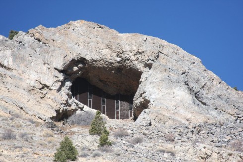
The steep hill at the mouth of Box Canyon across from the Wellsville bridge, just off U.S. Hwy. 50 east of Salida is a hard landmark to miss. Just below the summit is a massive hole that when the light is right, appears to be barred shut by some sort of fence.
Exploring seemed like a good idea until about halfway up, when the scrub brush hillside gave way to fields of sharp and loose scree. They were tailings, it turned out, a product of the mining activity that took place off and on over a 70-year period.
The hole and tailings are the remnants of limestone quarry and mining operations in the Box Canyon area. “It operated originally in the 1890s, and then reopened in the 1910s, and then again in the 1950s and 60s,” said Kyle Sullivan, information officer with the Royal Gorge office of the BLM, which currently administers the land.
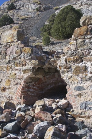
At one point, the travertine marble taken out of Wellsville was used in construction projects across the country, including the Department of Commerce building in Washington, D.C. The Box Canyon operation, less glamorous but no less vital, took out the limestone, which was cooked into quick lime and fertilizer by a network of kilns in the area.
Only one kiln remains relatively intact, at the base of the steep hill. Above the kiln is a steep, loose slope. The temptation to ascend the hill to explore the summit shaft quickly dissipates with the prospect of a nasty fall on the slippery and sharp tailings that blanket the hillside. But this is the most pleasant of the possible mishaps.
Beyond the kiln is a network of tunnels, much more accessible and no less curiosity-inducing. The impulse is to step into them and explore. The state Department of Reclamation and Mining Safety outlines the many reasons why this would be unwise. You could fall down a mine shaft. You could suffocate in pockets of oxygen-deficient air or toxic gas. You could get buried alive. You could get eaten by hostile life forms. You could blow yourself up with old dynamite. Fortunately, none of this is likely at the Box Canyon site, because the entrances to the tunnels have also been blocked by steel barricades that a gorilla couldn’t breach.
The barricades are the result of a joint effort by the BLM and the Colorado Division of Reclamation, Mining and Safety (DRMS). Since 1980, the DRMS has safeguarded more than 6,000 hazardous mine openings, as well as reclaimed over 1,500 acres of abandoned mining land statewide, including the Box Canyon sites.
Every closure or reclamation is a unique engineering problem. “We try to bid out the work to local contractors,” said Bruce Stover, director of the Inactive Mines program with the DRMS. “They know the area and usually have the experience.”
In 2013, the DRMS closed 445 hazardous openings, and expects to do much the same next year. With more than 23,000 inactive or abandoned mines and quarries statewide, there is still much to be done and much to be avoided. If you encounter an abandoned mine, the best thing to do is stay out of it. Hikers who encounter a hazardous mine are encouraged to report it to local law enforcement or to the state, and to enjoy it safely, from the outside looking in.
Ron Sering lives in Howard and does plenty of hiking, and only occasionally gets lost.


Ron, hello there. We were up close and personal to the box canon caves just around the wellsville and u.s. 50. we seen the closed up mine that you have here. After great thought we chose not to hike it , every thing seems real loose. We choose to head out, on our way down 50 only a couple miles to the east i made a right turn on to a nice and steep 4×4 road ( no signs). We headed up what looked liked an old creek bed that was now a 4×4 trail. We took this road up to a round tube fence. There was a no trespassing sign after that, we took a look around on the legal side of the fence and found three caves that are there. These caves were up the side of the hill, it looked liked they were one above the other but , maybe interlocked. Have you been up here, what are theses,mines or caves?. I’m looking at the map and it looks like B.L.M but again the only sign was at the end of this road. Do you have any knowledge of this place, if so please let me know. I took a photo of the lower entrance form the door way and when we got home and looked at my photo on the computer………There is what looks like a ghost monkey, and a lot of clear images of skulls and ghost like images in my photo. These photo’s made my heart drop like a roller coaster , they are damn clear!. Please give my a history lesson on this land and if there are recorded deaths of the 1800-1900 miners.