
By Kenneth Jensen
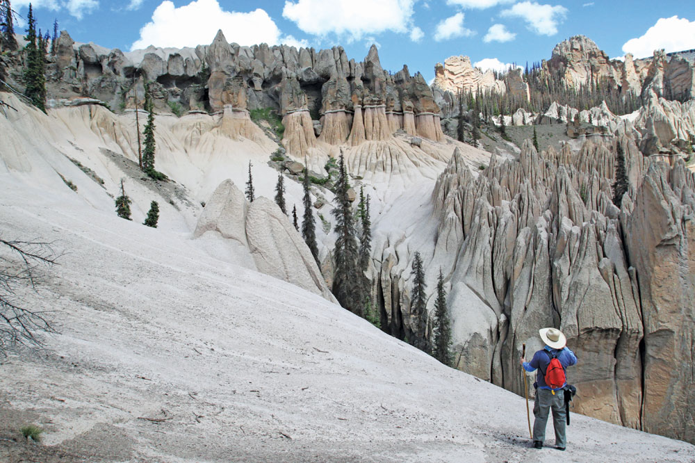
The Wheeler Geologic Natural Area northwest of Wagon Wheel Gap offers some of the most unique and beautiful formations in Colorado. The site has an interesting history. During the start of the mining era in Creede, the formations were accessible by horseback and not considered remote. In 1908, the site became so popular that it was designated by President Theodore Roosevelt as the Wheeler National Monument, named for George M. Wheeler, head of the 1874 survey of Colorado.
As time passed, people expected to drive to their national monuments. A better access road was planned to Wheeler, but never constructed. In 1933, because of its remote location, the area was de-listed as a national monument.
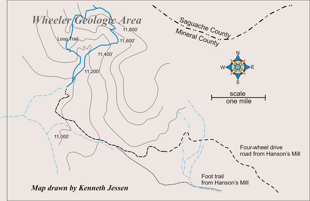
From the end of the four-wheel drive road at the area’s boundary, the foot trail climbs for a little over half a mile before reaching the formations. The trail takes the form of a loop that circumnavigates Wheeler. The western part of the loop (to the left) has the best views that look across Wheeler’s amazing landscape. Just beyond the start of the east side is a shelter cabin. Nearby is an informal side trail leading to a picturesque canyon with fluted walls. The loop climbs 830 feet and reaches 11,800 feet at its junction with the Halfmoon Pass trail.
Although the geologic area that was set aside is large, the formations themselves take up only about 60 acres. A light buff color, they vary from sharp pinnacles to a knife-edge ridge and rounded finger-like monoliths. They were formed by wind and water erosion attacking a layer of consolidated volcanic tuff (ash).
The surrounding forest is lush and dense although filled with dead trees – victims of the pine beetle. There is little surface water and the area can get quite warm in midsummer. Hikers should take adequate water.
[InContentAdTwo]
Wheeler is well worth the effort. However, reaching the trailhead requires negotiating 14 torturous miles of rocks, mudholes and fallen trees in a four-wheel drive vehicle. The trip takes up to 2 1/2 hours – slightly less for an ATV. A word of caution: any attempt to travel this road when it is wet or with rain in the forecast is not advisable. Even Forest Service vehicles have become stuck for days.
The alternative is a 7-mile hike just to reach the start of the 3 1/2-mile loop. Trail guides recommend making Wheeler into a two-day trip and camping near the trailhead.
Both the trail to Wheeler and the four-wheel drive road start 10 miles from Hwy. 149 at Hanson’s Mill at the end of Pool Table Road. This is a graded dirt road suitable for travel by automobile. The Pool Table Road turnoff is clearly marked and located just west of Wagon Wheel Gap.
Kenneth Jessen lives in Loveland and is always interested in the bizarre and unusual. Wheeler certainly falls into this category. He writes for this publication and creates two feature stories a week for the Loveland Reporter-Herald. Jessen also teaches adult education for Colorado State University on Colorado history.