By Phillip Benningfield
Imagine cursing a face full of persistent 25- mph wind, eating food like it was your last meal, being shocked by vistas beyond your expectations, and resting at an idyllic campsite. You’ll then have a very small taste of riding a bike along the Great Divide Mountain Bike Route. Throughout the quiet, the pastoral, the mountainous expanses of this spectacular region of Colorado, a serpentine route for bicyclists exists that takes one far away from local issues, errands and busy summer months.
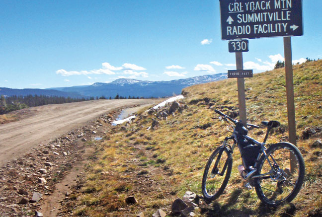
A portion of the Great Divide Mountain Bike Route (GDMBR) travels over 300 miles from Breckenridge, Colorado, over Boreas Pass through Como and Hartsel, across the Badger Creek drainage east of Salida, and up Poncha Pass to Old Marshall Pass. Once through Sargents and a highway stretch, the route turns south in bucolic Doyleville and immediately into rolling high desert after leaving Tomichi Creek. Further south along an actual flat stretch, one reaches the Cochetopa State Wildlife Area, then up and over Cochetopa Pass, then again up Carnero Pass past La Garita and Penitente Canyon. Along the western edge of the San Luis Valley to Del Norte the views of the Sangre de Cristos and Southern San Juan Wilderness are panoramic. Finally, the route climbs deeper into the San Juans to Indiana Pass (11’910’)– the highest point along the entire 2,745 mile route – to Platoro.
The GDMBR is an amalgamation of forest service roads, some paved sections, rails to trails and singletrack. More importantly, many volunteers and the American Cycling Association (ACA) have shaped the circuitous route. The original adventurous route was birthed from the efforts of two brothers from Wyoming. The Moe brothers rode a continuous mountain route along the Continental Divide in 1984 and the ACA finished mapping the route in 1999. Today, the ACA continually adjusts the route as roads are closed for reforestation and adds new sections as they become available. The entire route now begins in Banff, Canada and stretches the length of the Divide to the desolate town of Antelope Wells on the Mexico border.
Within Central Colorado, the memorable stops are atop Boreas Pass and the refurbished Denver, South Park and Pacific train depot. If you are lucky enough to walk around at 11,482 feet on a beautiful summer day, the historical buildings and views are not to be missed. Bring a lunch and take repose in the tall alpine grass before blazing down the pass towards Como. If time allows, stop at the Como B&B and enjoy tap beer, good food, and the friendly proprietors. As spoiled as one can get in Como, expect the opposite from Hartsel through Badger Creek, as the high and dry ranch land desolation and voracious wind will have a lasting effect.
The next section to Old Marshall Pass requires many calories, but the reward – in the late summer – is tasty raspberries along the road. In the Cochetopa area, the Dome and Luders Creek Campground offer classic Colorado views and a spring-fed water source at Luders. With enough leisure in mind, rent out the Forest Service Carnero guard station near Carnero Pass. The guard station allows a large group to join in on the fun with ample opportunities for hiking, side excursion biking, and even climbing nearby.
If the San Luis Valley and close proximity to a well-stocked store are your delights, linger and ride in and around Penitente Canyon with dirt roads and quality loops involving great singletrack. Lastly, for those who need longer climbs, ride the section from Del Norte to Indiana Pass. The road starts off friendly and rolling but changes grade as soon as dirt is encountered. Reaching the pass at 11,910 feet is well worth the effort, with spectacular San Juan mountain views, tons of side trail systems, and epic wind above tree line.
If you venture out on the GDMBR do not be foolish and go without copious amounts of water and food, unless you take the easy way and bring the car with a cooler full of libations. The route will test your legs and lungs while riding over the passes, but the wind will probably be the most draining challenge, especially along the stretches from Como to the Fremont County line, Doyleville to Cochetopa Pass, and along the San Luis Valley to Del Norte.
Mellow introductory sections for the newbie rider are the Boreas Pass rail grade (the elevation will be noticeable), Badger Creek, between Hartsel and Salida (on a still day), the turn off highway 114 to Carnero Pass all the way down to Penitente Canyon (near La Garita), and the first ten miles south of Del Norte. These rolling sections are a great place to take a kid who is learning to bike.
As I remember, learning to bicycle involved a cement parking lot and cars to dodge. Imagine learning to bike on a flat dirt road with soaring raptors, the bugle of an elk, no attentive bystanders, and aspen groves fluttering in the wind. For an adult or child, it’s a memory to look back on with iconic western appeal.
Adventure Cycling Association, www.adventurecycling.org, (800) 755-2453
Phillip is trying to finish his fifth Colorado guide while being overwhelmed with life!