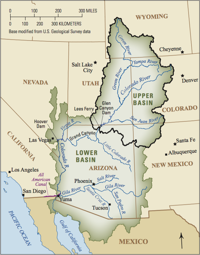

EL AGUA ES VIDA, OR TRANSLATED: WATER IS LIFE. The July ’22 issue of Colorado Central Magazine had no less than five items concerning water. The primary item was George Sibley’s article regarding the Colorado River Compact. With all that emphasis on the “life blood” of our region, state, nation and planet, this offering provides some more detail on our state’s namesake river. The river basin encompasses about 246,000 square miles with about 90% in the U.S. At the federal level, the basin is (mis)managed by the U.S. Department of Interior’s Bureau of Reclamation.
The Colorado River starts as a drip in the high country in the very northern tip of Grand County near to the Continental Divide, about 16 miles as the raven flies north of Grand Lake. With that first drop, the Colorado River then flows south by southwest for about 1,450 miles toward (but rarely to) the Gulf of California. Along its trace some major hydrogeologic features include Lake Granby, Lake Powell on the Utah-Arizona border, the Grand Canyon, and Lake Mead near Las Vegas.
Seven U.S. states and two Mexican states, not to mention at least 29 U.S. federally recognized indigenous tribes, rely on Colorado River water and are at the mercy of nature — specifically drought and climate change. At risk is the water supply for 40 million people. But also, all are at the mercy of bureaucrats and politicians.
During most years, Colorado River water never reaches its delta where, if it were flowing, the river would meet the Gulf of California. Perched along the trace are dams and their reservoirs, public and private lands, and commercial and industrial users. Ranchers, farmers, flora and fauna are all beholden to the weather cycles but also to the money- and water-grubbing attorneys representing the special interests of their clientele.
Most Western water law is based on the concept of “first in time, first in right.” The earlier a water right was established, the more senior it is. Senior rights are better than more junior rights, especially during times of drought, when junior water rights get no water until more senior water rights are satisfied. The Western system is much different from the Eastern Riparian System, which allows anyone to use water that occurs on their property.
Perhaps the biggest embarrassment for U.S. water policy is that indigenous nations have never had a seat at the table (until very recently). The “table” is filled with varying government agency bureaucrats, and their bureaucracy is overwhelming. The “table sitters” devised the Colorado River Compact in 1922 — 100 years of chaos (see George Sibley’s article in the July issue of CCM). Tribes along the Colorado River have been scratching for water and their very survival for 4,000 years — sounds like senior water rights.
A very telling citation from that 1922 Compact (again, written with zero input from indigenous nations): “Nothing in this compact shall be construed as affecting the obligations of the United States of America to Indian tribes.”
Other impositions upon the tribes and nations include, but are not limited to, the Indian Appropriations Act, the Indian Intercourse Act, the Colorado River Indian Irrigation Act, the Winters Doctrine (and the list goes on). Akin to the reservation system, U.S. water policy was historically crafted deliberately to eradicate Indigenous peoples and their way of life. What treaty, what pact, or what promise has the U.S. government ever honored when it comes to the inherent discrimination and racism of Manifest Destiny?
The current chaos involves the Colorado River Basin guidelines that were instituted in 2007. Those interim guidelines were put in place by the seven U.S. states — all without input from any indigenous person or from Mexico. The 29 federally recognized tribes within the Colorado Basin hold senior water rights that account for 20% of the river water. The Biden administration indicates that these guidelines are a “critical project” and that the flows and allocations should be finalized in 2026. (The interim guidelines expire in 2025.)
The tribes are forced to band together to fight for and demand that their water rights be recognized and that promises made (and treaties and pacts) be honored. But they’re still confronted by the colonialism of politicians. Lawsuits are moving at a snail’s pace through the various court systems. Colorado Basin states are suing each other because even the two U.S. regions — delineated as Upper Basin and Lower Basin by the Compact — don’t get along. The Colorado River Indian Tribes, the Colorado River Basin Tribes Partnership, the Colorado River Water Users Association and other alliances are making slow progress; but oftentimes, it’s one step forward and two steps backward.
The U.S. Supreme Court had to settle an interstate rivalry (Arizona v. California) so that the Tribes didn’t lose their senior rights. When did this happen you might ask? 1964. And where are they today? Still fighting. Court cases languish for decades. As an example, Congress passed a bill in 1992 that awarded the Jicarilla Apache Nation their rights — a court battle that started in the early 1970s. As well, the Mexican Water Treaty of 1944 allotted to Mexico a guaranteed annual quantity of 1.5 million acre-feet of Colorado River water.
Rarely is the riverbed naturally wetted south of the border. Upstream allocations and diversions, evapotranspiration, and drought prevent Colorado River waters from ever reaching Mexico. Ever since the 1960s, when the Glen Canyon Dam began the filling of Lake Powell, Mexican soils have been dry. Mexico still receives Colorado River water in accordance with the 1944 Treaty, but only via man-made infrastructure (not by natural flow). With the Morelos Dam (just across the border in Mexico) along with pipe/tunnel and irrigation ditches does Mexico receive Colorado River water.
In the spring of 2014, a test release resulted in a pulse flow of just over 105,000 acre-feet. In the summer of 2021, another pulse flow sent 35,000 acre-feet onto Mexican lands. Both of these pulse flow releases were part of habitat restoration projects for the Colorado River delta. Only through these deliberate releases does water “naturally” flow the 100-mile trace south of the border to the delta and the Gulf. But now the U.S. Bureau of Reclamation has declared emergency conditions in the reservoirs — water levels are getting too low to even power the dam’s hydroelectric turbines.
A primary problem is that the 1922 Compact’s allocations to the parties of record (throughout the basin) were to be equally distributed, but those allocations were based on false hydrology. The river’s alleged 16.8 million acre-feet was overly optimistic. A more realistic number is perhaps 12 million acre-feet.
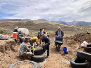
The future forecast is bleak with climate change, drought, unfettered population growth, unrelenting bureaucracy and a growing number of attorneys. And, Colorado’s Front Range metropolises are coveting everybody else’s water. Follow the money, and beware consultants bearing gifts. Last year, the Chaffee County Commissioners caved to Nestlé (now known as BlueTriton) by extending its 1041 permit. On behalf of Douglas County, Renewable Water Resources even tried to use the American Rescue Plan Act to fund their speculative water project. Fortunately, those county commissioners voted “no” (for now).
As Albert Szent-Gyorgyi once said, “Water is life’s matter and matrix, mother and medium.”
Bill Christie holds an advanced degree in Environmental Science and sips his water very gently in rural Custer County.