By Alan Robinson
Readers of this magazine may recall the September 2008 article on “The Stage Road from Canon City to Leadville.” There I summarized the history of that 1870s passenger, mail and freight route, and 1880 construction of the long-abandoned Colorado Midland Railroad (CMRR) through Chaffee and Lake Counties. I also asked rhetorically if in today’s environment, where preservation of our area’s cultural heritage is increasingly recognized as important for both social and economic reasons, there might be an opportunity to develop a long-distance public heritage trail along those routes. The initial vision was to connect Buena Vista and southern Lake County with a slow-speed pathway of about 30 miles – some sections for vehicle travel, some for hikers, cyclists and horseback riders – which would celebrate the stories of those two routes, stimulate preservation of their deteriorating physical features, interpret their history to strengthen the public’s appreciation of their value, and in some cases, make sections now inaccessible open to public use.
Much has transpired since that first vision was floated as an idea for discussion in 2008. This article will bring you up to speed on what has happened and what is likely ahead. But first, a little refresher on the historical routes that inspired the concept. (See the September 2008 issue for much more detail.)
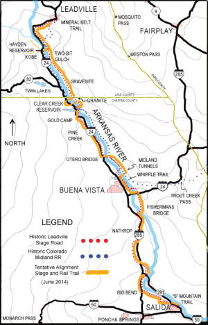
The accompanying map shows historical routes of the stage and CMRR, as well as trail ideas now developing. Basically the Cañon City to Leadville stage was constructed beginning in the 1860s as one way of getting passengers, mail and freight to the booming new Leadville mining districts. As the Denver and Rio Grande (D&RG) developed its narrow gauge tracks up the river and valley in the 1880s, the stage departed first from Cañon City, then from Salida and ultimately from Buena Vista, meaning a jolting 26-hour stage ride for the full 126 miles was shortened to about 35 miles and six hours. When the D&RG reached Leadville in late 1880, use of the stage road dropped dramatically, although it continued to be available for local freight for some time. Early 20th-century motorable roads sometimes followed the old stage route, obliterating it except for obvious remnants north and south of Granite in northern Chaffee County. The standard gauge Midland coming over Trout Creek didn’t reach Leadville until 1885, paralleling both the D&RG and the older stage road. But in spite of many tremendous engineering achievements (from multiple tunnels north of Buena Vista to ambitious curving trestles and tunnels crossing Hagerman Pass), the CMRR did not remain active much past the early 1900s.
Residents and frequent visitors to Lake and Chaffee Counties probably best know the stage road from its lingering hand-constructed retaining walls north and south of Granite, seen from U.S. 24. A Collegiate Peaks Scenic and Historic Byway interpretive exhibit just south of Granite focuses on that story. Just north of Buena Vista on CR 371 are the locally famous Midland Railroad Tunnels. The potential Stage and Rail Trail would pass along both those iconic stretches, but there are many other less obvious pieces that could be incorporated. For example, in the broad and beautiful Hayden Valley south of Leadville, the stage road passed just east of the river, and today still offers spectacular views – and close access – to the publicly owned east bank of the Arkansas.
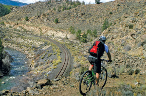
The stretch of the old CMRR north of the tunnels, now called CR 371, is already tremendously popular with cyclists, rafters and fishermen. South of Buena Vista in Chaffee County, the stage road is less traceable, but a route along county roads and some paved state and federal highways would closely approximate the original route all the way to Salida. Although suitable for mountain biking, these public roads are open to licensed vehicles for slow-speed scenic cruising and appreciation. Even some Salida natives might not be aware that CR 163 along the river was likely the old stagecoach road.
Although both the stage and CMRR routes have long been abandoned, enough remnants and alignments can still be traced, much of them on public lands or incorporated into today’s county roads, to raise the question of whether it would be appropriate or feasible to stitch them together into a modern public trail. To explore that question, in 2009, I, along with others, approached local nonprofit association GARNA (the Greater Arkansas River Nature Association) for their sponsorship of a grant application to assess the feasibility of establishing such a trail, referred to now as the Stage and Rail Trail (S&RT). With matching funds and support expressed by many potential partners, including the Lake and Chaffee County Commissioners, Arkansas Headwaters Recreation Area, U.S. Forest Service and BLM, and the towns of Salida, Buena Vista and Leadville, our application to the Colorado State Trails Program was successful. From 2010 to 2012, we undertook a feasibility study (available through GARNA’s website, www.garna.org) complete with historical research, input from partners, contacts with private land owners and small local communities, and open public meetings. One significant change over the initial vision was that, at the request of both the Lake and Chaffee County Commissioners, the scope of the trail was formally extended to include reaching the municipal boundaries of both Salida and Leadville, making its overall length about 64 miles.
Overall, the final feasibility study in June 2012 concluded there was sufficient public support for moving forward to a more detailed “Master Plan.” On the positive side, the study concluded there would be substantial economic benefits related to increased “heritage tourists” choosing – and staying in – Lake and Chaffee Counties. The potential for historical interpretation is high for visitors, local residents and students alike, leading to greater appreciation of early transportation routes and thus to support for needed preservation efforts. Opportunities to actually hike or bicycle along sections of the route contribute to the diversity of recreational options along the river corridor and directly address the area’s growing demand for these fun fitness activities.
To be clear, in addition to expressions of support, there were also expressions of concern over possible negative impacts, especially related to opening or promoting a physical trail in areas where it would pass through or get close to a small community, such as Granite, or where it might approach or pass through private properties. Flags were raised by specialists of Colorado Parks and Wildlife and others regarding potential impacts on wildlife, in particular bighorn sheep and elk near Granite and raptors along the river.
Now, in 2014, our GARNA-sponsored team obtained a second grant, with support from the same partners, to complete a Master Plan, tentatively scheduled for completion this fall. It’s important to understand this is simply a draft that the partners will then consider for implementation. Only when a partner has accepted responsibility for a trail segment or a proposed development (interpretive site, parking area or trailhead), off-site activity or future maintenance would those activities be implemented. Neither GARNA nor the planning team are decision-makers in terms of implementation.
Now at about the mid-point of planning, July 2014, the shape of what will eventually be proposed is coming into focus. This is being periodically “tested” for its practicality and its likelihood of being accepted by partners. Before taking final form, it will be brought to the public at large, private landowners and other “stakeholders” for an opportunity to comment.
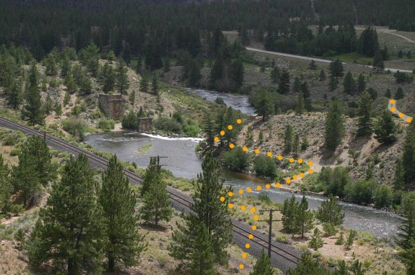
 Looking again at the map, you will see we’re trying to hold true to historic routes, but we are also responding to concerns of Granite residents, private landowners and wildlife specialists by suggesting diversions from the historic rights of way. For example, we’re considering proposing pedestrian bridges over the Arkansas River both north and south of Granite so that the trail would not actually run through the small community. Another bridge just north of Clear Creek would avoid switching the proposed alignment from the stage road to the CMRR at that point, which had originally been intended. This is partly in response to concerns of private landowners to the south along the CMRR that public access might infringe on their privacy, lead to conflicts or have a negative effect on property values. But such a bridge would also lead the trail away from bighorn, elk and nesting raptor habitat that wildlife specialists have identified as sensitive.
While we are pursuing options for making sections of trail open to hiking, biking and horses, we’re also suggesting additional interpretive opportunities along U.S. 24 so that driving visitors can have an opportunity to appreciate the S&RT’s historical significance without actually being on the trail. And note that from north of Buena Vista all the way to Salida, the anticipated proposed alignment would follow public county roads or state or U.S. highways. If not actually on the known stage route, the S&RT would follow it in spirit, with many opportunities for historic interpretation and slow-speed appreciation of the historic scene. Similarly, as the likely alignment approaches Leadville to the north, it would either follow along U.S. 24 where the original stage road probably went, or divert to public lands to the west on open roads not involving impact to private lands.
So the idea of a 64-mile-long heritage trail from Salida to Leadville is moving ahead! Challenges in details remain, but the overall vision to provide significant preservation of physical remains, interpretation of historic significance, and a measure of physical experience on the old routes is intact. Stay tuned – and informed – by visiting www.garna.org or Facebook: Leadville Stage Road.
Alan Robinson lives in theoretical retirement north of Buena Vista in Chaffee County after working nationally and internationally with protected areas and community-based ecotourism.