
By Polly Oberosler
Editor’s Note: Back in April of this year, a massive rockslide occurred on Schofield Pass, a four-wheel-drive forest service road which connects the towns of Marble and Crested Butte.
Popular with mountain and dirt bikers, hikers and Jeep enthusiasts, there was speculation that the sheer enormity of the slide might permanently close the pass, which was originally built in 1883 as a wagon route between the two mining towns. But, on June 8, after three days of work by a dedicated crew of U.S. Forest Service employees, F.S. Road 314 has reopened.
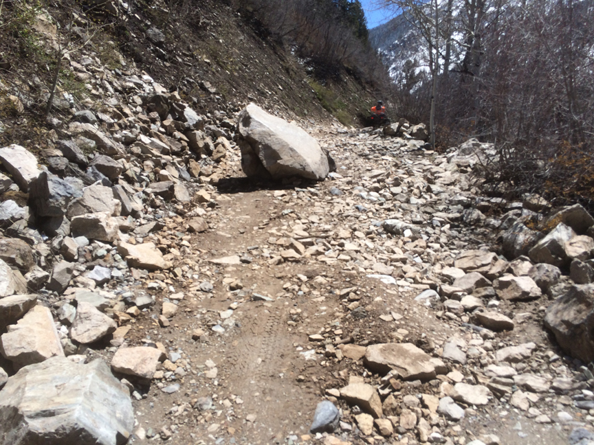
The work was overseen by Jim McBreen, construction and maintenance supervisor for the USFS He described very large trees above the road that were shattered by the slide and reported that one of the holes in the road was nearly 16 feet wide and 4 feet deep. He estimated that nearly 100 yards of road were affected by the slide. A bulldozer team consisting of Larry Augustson and Salvador Landa did much of the road clearing, despite the difficulty of bringing the machine up to the remote location.
Jeepsters and other local four-wheeling clubs regularly perform volunteer work on the road, but this slide was a bit outside of their ability levels. We asked sometimes contributor and Gunnison Valley native Polly Oberosler to share some insights into the pass with us.
Colorado miners in the 1800s traveled through the mountains to gain access to the rich ores locked in the high cliff faces and streambeds. They used parts of game trails and footpaths already tromped by the Paleo and Ute Native Americans to more naturally access areas that held the ore they sought. But, if ores were found in quantity, they enlarged the routes they used to accommodate pack strings of donkeys and mules, and later wagons, for hauling the ore to mills in the lower valleys.
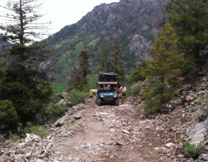
Schofield Pass was one such route. Part of it was hacked out of a rock face to allow the passage of wagons to haul the silver ore from the town of Schofield in the Sawatch Range. The pass has always held a mystique because a section of the road is literally hanging from the cliff face and is above the wildest part of the roaring, frothing creek below. Huge boulders fill the creek ,testament to the wildness it passes through. There are car parts strewn along a few sections of the pass to remind you this is no pilgrim route.

In the 1880s, Al Johnson, a locally famous skier, and his brother snowshoed the length of the primitive road in winter, from the town of Crystal to the mining camp of Schofield, to deliver the mail and small supply items. It was incredibly treacherous and on the worst part of the “road,” but Al Johnson made it through every time, and there is still a ski race held in his honor every spring at Crested Butte Mountain Resort.
I was first over the pass as a kid in a Willys Jeep with my parents in the early 1960s, and I remember part of it being a bit scary. By the time I drove it in my own Willys, the road had deteriorated to the point that at times all four tires were not on the road at the same time. Also, the vehicle dropped off ledge after ledge of sheer rock as we descended into the canyon.
[InContentAdTwo]
One year in early June my Mom, my husband, our kids and I left Crested Butte in my Willys to see just how far we could get up into the hills. We easily got around Emerald Lake at the top of the pass and across Schofield Park, then pushed on down the boulder-covered old streambed that serves as the road for a bit. We crossed the Crystal Creek, where I duly dried off my brakes as the sign warns you to do, and dipped into the canyon.
To say that I was swallowing hard after that first turn is an understatement; that is the point of no return. I made everyone get out to lighten the load, and in the lowest gear possible descended to the canyon bottom where everyone loaded up and I got my color back. Across the bridge and around the corner I went, feeling accomplished, and there in front of me was a two-hundred-yard wide patch of avalanche across the steep hillside with the river running under it two hundred yards below. My heart sank. There was no way I was going back up that punchbowl road, climbing it would be certain death if I were to stall out and I said as much to the passengers.
We sat there, pondering this misjudgment when my husband noted there was a lot of rock above that avalanche that could be used to anchor my jeep to the hillside, so we began to roll rock down the hillside. Three other rigs came up behind me; two stayed to join in the thrill-seeking we were about to partake in, and the third called us crazy and left.
After finishing with the rocks, I got in, turned on the engine, and swallowed hard. My husband told everyone to get on the downhill side of my jeep to hold it in order to keep it from rolling into the river, and with them walking me down, I started out. My husband eventually let me know I was on my own once I passed the rocks they had placed on the snow. I went up a gear to keep it under traction and by the time I got to the bottom, welcomed by two dozen cheering hikers, I was in fourth gear. The other two Jeeps got down assisted by the ruts I had set for them.
I can’t say I am proud of being so stupid to even get in that position, but I pulled it off when I had to and no one died. We went over it a few more times after that, one of which was on our honeymoon, but never again in June. We hear news that a part of that road is gone this spring, nature’s way of closing a trail or road, by rockslide and erosion. I do not know if it can be reopened, but sometimes things are better left as Mother Nature intended.
Polly writes because she is not busy enough being on one nonprofit and three county boards. Life is too short to relax.

I took my family “Up” from the Marble city side to the (DP) Devil’s Punchbowl and over into Crested Butte on the second week of August 2015. The FOREST SERVICE should be commended for all their work on the road ! The climb up adjacent to the DP on what I term the Devil’s Ledge is a cambered tilt toward the Crystal River, below is sharp bedrock and should not to be taken lightly. This section of road may only be a quarter mile long but is the most treacherous and nerve racking portion that should only be driven (very slowly )and by experienced drivers! My daughter spotted me on the Devil’s Ledge and up creating a line that allowed me to avoid scraping or banging the suspension! In my wife’s opinion, this trail is by far more difficult and cumbersome than Black Bear Pass and its infamous switchbacks! Spring 2016 has seen some heavy snowfalls and leads me to believe that if DP is attempted this year it will be very late in August or early September to assure the road is clear of snow drifts. The drainage ruts caused by runoff on this portion of road will eventually make this road impassable in this quarter mile section and either the road will need to be widened or closed, but that is decision that is still a few years off. Do not do this alone, you need a spotter to go up the road to make sure no one else is on it at the same time! And remember to STAY THE TRAIL !