By Tom Purvis
When spring came to Salida back in 2004, the Bureau of Land Management (BLM) announced their plan to conduct a travel management planning process on their managed lands in the Upper Arkansas Valley. The trails that were available near Salida were few, rough, and not constructed sustainably. To say they were constructed at all was a stretch. But we loved them and feared having the BLM declare them unsustainable and close them. A group of trail lovers—mostly mountain bikers but not all—came together to defend our meager trails. We wanted to at least have a chance to argue for their continued existence, and to offer to help resolve issues with the trails to that end.
We met the BLM folks and established a rapport. We offered to help them inventory trails. Several of us bought GPS receivers for that reason. We met frequently. At that time we were known as the Arkansas Valley Cycling Club.
One day, not long after we’d had a meeting, my friend called and raised a point that changed our focus. These are our trails and this is our land, why are we being defensive? Why don’t we tell them what we want?
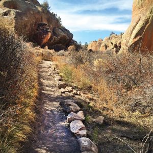
After that we went on the offensive. We became Salida Mountain Trails (SMT), a group to represent all trail users in our part of the county and not just cyclists. We used our GPS units to map out a plan. We walked routes that did not exist and put them on maps. We learned about trail design and trail system design. We wrote a plan that came with maps and raw GPS data. There were two stacked loop trail systems, one north of town in the Arkansas Hills and one south of town on the north slope of Methodist Mountain. In March of 2005 we submitted the Salida Mountain Trails Park Proposal to the BLM. It became an official part of the Arkansas River Travel Management Plan.
Then we went to work promoting the plan. We went to city council meetings, county commissioners’ meetings, BLM Citizen Advisory Council meetings.
Then nothing else happened for a very long time.
In early 2006 we created a trails project that could only be done with the permission of the city because it was entirely on city property. We started and finished work on the Tenderfoot Trail in April of 2006.
The dream of building out our plan could very easily have died during that time. Those of us who created the plan were feeling a little disgusted. We knew of trails on BLM land in Colorado that had been built bootleg under the table and then later blessed by BLM. We were trying to do it the official way, the legal way, and we were getting nowhere.
Finally, in summer of 2007 the BLM conducted a public meeting to present plan alternatives and open the comment period. In December of that year, a plan alternative was selected. There had been some staff changes in the BLM’s Royal Gorge Field Office in Cañon City, and SMT began seeing invitations to submit project corridors for the National Environmental Policy Act review (study of potential impacts on plants, animals, archaeological sites, etc.).
In June of 2008, a plan was submitted to the city for what became the Li’l Rattler Trail. Work began in September. In November the first trail on BLM land was approved and work began on the Backbone Trail from County Road 173 to Sand Dunes Trail.
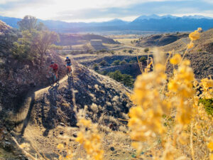
The next several years saw lots of trail miles being built, mostly by volunteer labor. The organization rarely had more than $200 in its treasury. The city and county governments hired the Southwest Conservation Corps to work on several projects and they were a very good partner, and their crews were often joined by volunteers.
Today, SMT plans new projects, since the trails on the 2005 plan have been mostly completed. Those new trails are almost exclusively professionally built. And today, SMT is looking for a part-time paid Executive Director. The community now understands the value of trails and supports the local organization that provides and cares for them. A far cry from the days when we only hoped to be able to keep using the handful of rough trails that were here.
Visit www.salidamountaintrails.org for more info.
Tom Purvis has twenty years of experience being a geezer in the Upper Arkansas Valley.