by Tom Karnuta
The follow article is Part One in what hopes to be an ongoing look at the geologic history found within the Arkansas Headwaters State Recreation Area. Future articles will take the reader from the headwaters of the Arkansas River near Leadville, down both highway and river, ending in Cañon City.

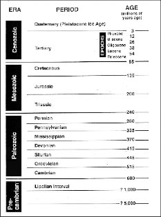
The very essence of geology begins with some small understanding of time, which in itself is somewhat daunting. Toss in terms such as Precambrian and Mesozoic to the mix and it becomes downright scary. In reality these terms are much easier than looking at a number followed by a half dozen zeros. As you start to follow the story refer to the geologic time scale provided. Knowing how many years ago the Precambrian Period occured is not as important as understanding that rocks from the Precambrian are older than rocks of the Mesozoic.
Leadville to Buena Vista – The Headwaters of the Arkansas River
The upper Arkansas River flows for a distance of 120 miles between Leadville and Cañon City, passing through the southern Rocky Mountains of Central Colorado. The river begins at an elevation of 10,000 feet in the Leadville area and eventually flows into the Mississippi River south of Little Rock, Arkansas. Through this distance the Arkansas River Flows through broad basins characterized by step-like terraces and narrow canyons cut through crystalline and metamorphic rock.
The primary topographic features of the 60-mile region above Salida include two mountain ranges separated by a valley that contains the Arkansas River. To the east the Mosquito Mountain Range includes several peaks with altitudes above 14,000 feet. This range consists of Precambrian crystalline rock overlain by sedimentary rock with a prevailing easterly dip. To the west, the Sawatch Range also displays elevations above 14,000 feet and consists of Precambrian crystalline rock, overlying Paleozoic and Mesozoic rock with a prevailing westerly dip and Tertiary intrusive rock. The 14,000 foot Collegiate Peaks, which include Mount Harvard, Mount Yale and Mount Princeton, are all part of the Swatch Range.
Between these two mountain ranges lies the Upper Arkansas River Valley. The valley width averages between three to ten miles in the Leadville area, narrowing as it approaches the town of Granite. The floor of the Upper Arkansas River Valley is approximately 4,600 feet below the tops of the Sawatch and Mosquito Ranges. Water running off the Sawatch and Mosquito Ranges flows across the valley and into the Arkansas River, providing the source for the river. Exceptional example of glacial valleys, moraines and outwash are well exhibited along the highway and river between Leadville and Buena Vista.
Tom Karnuta has a Masters Degree in Earth Science from the University of Northern Colorado and has worked as a geologist in the Upper Arkansas Valley for 18 years. He is author of the book, Road and Riverside Geology of the Upper Arkansas Valley.