We often forget that what we know might not actually be accurate. Human nature rests on a mountain of assumptions, and in ignorance, we often mistakenly believe we know more than we actually do. Mountaineer, and Seattle University based engineering professor Eric Gilbertson, has made a full-time hobby of questioning the highest points in every nation on earth.
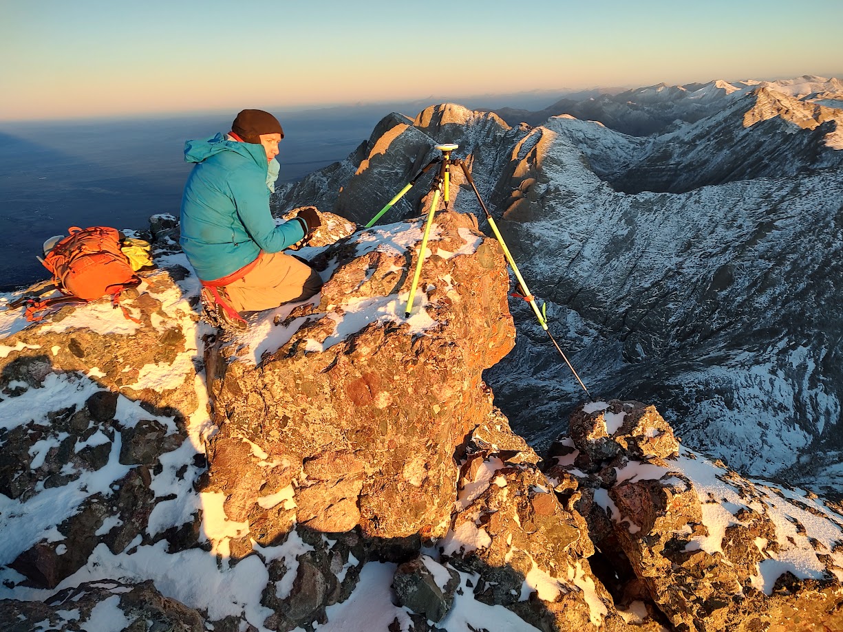
On October 5, Gilbertson and two colleagues, Elijah Gendron and Peter Klein, climbed the 14,299-foot Crestone Peak in the dark, arriving at the saddle between the summits of Crestone and an almost-as-tall bump called East Crestone at dawn. What the three-man crew wanted to know was which one of the points was taller. After using sophisticated equipment mounted on both rocky peaks simultaneously, Gilbertson demonstrated with a 99% confidence probability that East Crestone was actually 3.6 inches taller than Crestone. This means that he discovered a new 14er in the Sangre de Cristo Mountain Range.

The two summits are around a football field’s distance from each other, separated by a 40-foot saddle that connects both of them. Using state-of-the-art equipment that triangulates the mountain’s altitude with passing satellites, Gilbertson was able to verify that East Crestone is just a smidge taller.
Gilbertson was generous with his time in a recent phone interview with the Tribune. The conversation has been edited for clarity and length.
Tribune: So, tell us a little bit about how you got into challenging official height measurements?
Eric Gilbertson: Oh, it’s probably started with my bigger project, which is climbing the highest mountain in every country in the world. I figured out that some countries haven’t been surveyed as carefully as in the US, so in some countries, it’s not actually known which is the highest mountain. For example, in 2018, I went to Saudi Arabia to try to climb the highest point there. I did some research and found that there are actually two mountains, and no one knew which one was taller. They had never been surveyed carefully enough, so my brother and I rented professional survey equipment and brought it over. It turned out that a peak no one had ever heard of, Jabal Ferwa at 9,848 feet, was 9.84 feet taller than Jabal Sawda, the one that locals assumed was the tallest. So that kind of got us thinking that other countries might not have been surveyed carefully enough. So now we have discovered five other new country high points.
Tribune: That is a fascinating way to look at the world. Tell me a little bit about the equipment because you are challenging whole nations on their facts, so you’d better be pretty sure about the accuracy of your measurements.
Gilbertson: Yes. I have a PhD in Mechanical Engineering from MIT, so I was used to working with a lot of scientific equipment for publishing research papers. One of the classes I teach at Seattle University is a mountain survey class, and it has a lot of surveying equipment, so that I can borrow some from them.
Tribune: Give me the “For Dummies” version of how this equipment works at measuring the height of mountains?
Gilbertson: There are a lot of different ways you can measure it. What we did for Crestone was I brought a professional GPS device up there called a Differential GNSS Receiver. What that really means is it’s just a really accurate device that collects information from satellites. How it works is that there are satellites sending signals down to earth all the time, and this collects all those signals, measures the distance to the satellite, and uses all of those measurements to calculate its exact latitude, longitude, and elevation.
Tribune: So it is basically using satellites for triangulation?
Gilbertson: Yeah, you can think of it as if you just pick up one satellite, it’s not enough, you actually need four, and then you can know your position. But if you get, like, 30 satellites, it becomes even more accurate.
Tribune: That’s really interesting because I’ve always wondered how they were even doing this surveying before satellites? How did they get accurate heights, say in 1900?
Gilbertson: They measured angles with a theodolite, a precision instrument that features a telescope that measures horizontal and vertical angles. If you can place the theodolite at a location of known elevation, and then measure an angle up to the summit, you can take a couple of different angle readings and, using trigonometry, figure out the elevation.
Tribune: The problem is, how do you determine a known elevation from sea level?
Gilbertson: It was a lot of work. What they did back in the 1920s was use tide gauges all around the US so they could figure out what the actual sea level was at each of the tide gauges, and then what they did they took measurements from the coast at zero, and they worked their way all across the interior of the US from that first spot.
Tribune: That is so epic!
Gilbertson: There were so many thousands of miles of measurements, and then they established, and then those are what the old measuring points are based on. They have been updated since then, but they were actually very accurate.
Tribune: So what made you want to look at Crestone in particular? Because it’s a high mountain, but it’s not the highest in Colorado, so what caused you to zero in on East Crestone versus Crestone Peak?
Gilbertson: Well, in 2020, I spent the summer in Colorado and some nearby states, and I climbed all the 14ers and all the Centennials (the 100 highest points), so I’m kind of familiar with the area, and I definitely like climbing the correct mountains on the list. I want to be as rigorous as possible now that I am into surveying. After I finished all that hiking, my friends showed me new Lidar Data (remote sensing technology that uses a pulsed laser to measure distances and was mounted in an airplane operated by the United States Geological Survey) that was published in 2021 and made public. The new data switched around the Centennial List a little bit, which screwed up my past efforts. It didn’t affect the 14ers, but some of my friends in Colorado were looking at the data, and they said Crestone and East Crestone were actually really close based on Lidar measurements.
Tribune: So you got that itch that you had to know that you actually have summited the tallest point.
Gilbertson: Yeah, and actually, what we think happened is that the Lidar might have picked up a person on Crestone, and so artificially measured it a little bit too high. We can’t be certain, but there’s no 4-foot spike right on the summit; a four-foot difference could be due to a person sitting or standing on the summit. Further, there is a big boulder on the top of East Crestone, and the Lidar only hits every few feet, so it could have missed that boulder, lowering the height. But our measurements captured the boulder and the summit of both peaks at the same time. And East Crestone is .30 feet taller than Crestone.
Tribune: So what do you do now with this data?
Gilbertson: So what I’m doing is I am submitting this data to a scientific journal. But I think that’s about it. I’m not quite sure how you make something like this official and publishing it in a peer-reviewed scientific journal because that is what I know what to do.
Tribune: I was just wondering if there is a USGS committee that makes lists of the tallest peaks. There is a committee that names peaks.
Gilbertson: My experience with USGS is that they aren’t really interested in the lists hikers use of the tallest mountains. I once submitted a change to the highest peak somewhere else, and the USGS was like, “That’s nice, but we don’t care, have fun.”
Tribune: Any final thoughts that you would want readers to know about your grand adventure in the Sangres?
Gilbertson: East Crestone is right next to Crestone. It’s not too hard to go out of your way and tag it. If you’re going to do one, you can easily do both and add 30 minutes or something.
To read more about the Gilbertson brothers bagging peaks around the world and for more information on the Crestone mission, visit their website www.countryhighpoints.com.
– Jordan Hedberg