by Mike Rosso
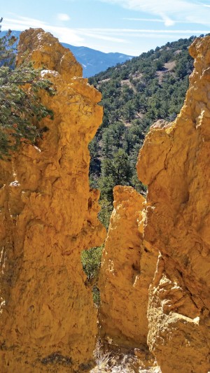
About five miles outside Salida is an unusual rock formation nicknamed “The Golden Towers” or “The Golden Spires.”
The composition of the hill containing the bowl in which the Golden Towers sit, and much of the side slopes of the bowl is mostly Volcanic Welded Tuff, broken into small- to medium-sized rocks that make walking in and around the bowl quite unstable. The presence of this welded tuff (volcanic ash compressed into rock) is unique to this hill in this immediate area, which is surrounded by rocks of the lower Paleozoic Era, according to area geologist Bob Hickey.
He states that the presence of this tuff, with no other signs of volcanic rock in the vicinity, indicates very localized volcanic activity.
[InContentAdTwo]
“After a short study of this area on a hike with a number of local geologists, we came to an initial conclusion that the hill was formed by local volcanic activity and the towers may have been formed in the side of the hill by either a small lahar, (a mudslide of volcanic ash), or a maar, – a shallow volcanic crater with steep sides surrounded by volcanic ash deposits and formed by one or more underground explosions that occur when hot magma comes in contact with shallow groundwater to produce a violent steam explosion. This explosion crushes the overlying rocks, which usually travel straight up into the air and fall back down to form the deposits,” Hickey suggested.
“The rock formations in the area of the bowl are of the Devonian Period, and these rocks are found in and around the Golden Towers. It is likely that after formation and settling, the bowl containing the towers was eroded by water, a process still continuing today,” he concluded.
Type of Hike: Day hike, out-and-back via the same route
Difficulty: Moderate, due to distance and scrambling at the towers (not for ages under 10)
Total Distance: Approximately five miles round-trip
Start Elevation: 8,700 feet
Highest Elevation: 8,800 feet
Lowest Elevation: 8,350 feet near the Golden Towers
Approximate Hiking Time: Five hours with breaks and lunch
Pace: Relaxed pace with breaks
Trail Conditions: Class 1 path/wash walking all the way except at the end, where there is steep, loose rock if you wish to climb around the towers (doable with care and a hiking stick or poles)
Directions to Golden Towers: At the Heart of the Rockies Regional Medical Center on Hwy. 291, turn east onto C.R. 175.
Drive to the end of the paved road and continue on a dirt road (Ute Trail) for 4.1 miles.
Pull into a flat area suitable for parking. (If you get to the Cottonwood Trail parking lot, you have gone too far.) There is a shot-up metal sign at the edge of the parking area that reads “Closed to Motor Vehicles.”
Straight across Ute Creek gully is a 9,000-foot hill; to the right, another. Cross the gully, go under the power lines, and angle uphill to your right between the hills.
On the other side of a grassy pass is a gully – the north fork of Deadhorse Gulch. Follow it down for about forty minutes to its confluence with the main fork. A ponderosa pine has fallen across the gully just below the confluence.
Follow the main fork downhill for about ten minutes to the first major side gully on your right. There should be two cairns there. Go up the side gully to the Golden Towers on your right.
To return, go up the main gully to the fork by the ponderosa tree and go to the LEFT. (The right, main fork goes through private property – please respect it.) Follow the north fork gully to the grassy pass and parking lot.
(You can also get to the Golden Towers by taking the North Backbone trail to Deadhorse Gulch and going uphill. It is prettier, but it is twice as far and more difficult.)
Thanks to Wayne Iverson for trail directions to the Towers, and to Bob Hickey for geological information and trail specifications.