
By Ericka Kastner
I’m pretty sure I’m going to regret telling you about this trail. It’s long been one of my favorites – this is the spot where I go when I need a day knee-deep in wilderness. This is the trail that I keep quiet about, only inviting certain people along to experience the route. So, I guess I’m officially inviting you.
I suppose my change of heart is because on more recent visits to Cottonwood Creek Trail I’ve noticed that two things have changed. First, it’s become rare that I’m the only one wandering along Cottonwood Creek on any given day. And second, this is likely because a few years back, the National Forest Service erected an informational kiosk at what has now officially become a trailhead.
[InContentAdTwo] I first discovered this trail many years ago while on a seven-day winter retreat at the Crestone Mountain Zen Center. Rising at 4 a.m. each day for a couple hours of early morning meditation typically led me to feeling restless by early afternoon, and in need of a hike. On my second night at the center there was a good amount of snowfall overnight, so the next afternoon I walked down the driveway in my snowshoes and turned left, setting out initially to walk along Dreamway Road in order to stretch my legs. Eventually though, I came to a creek crossing. Just before the creek’s intersection with the road, I saw a barely noticeable, slightly deflated area in the snow towards the creek drainage, indicating a possible trail. Not one to miss an opportunity to explore, I indulged my curiosity and headed into the woods on what became a magical, almost mystical, snowy wilderness hike east along Cottonwood Creek and into the Rio Grande National Forest.
It wasn’t until I returned to Cottonwood Creek Trail the following summer that I was able to discern how barely broken-in the trail truly was at the time. In fact, only the first couple of miles were well worn, and before too long, I was left to follow cairns, trusting intuition and orienteering skills in order to continue the route. On many occasions since, I’ve done exactly that, traveling further and further each time; in return I’ve been treated to mind-blowing solitude, natural wildness and deep inner peace along Cottonwood Creek.
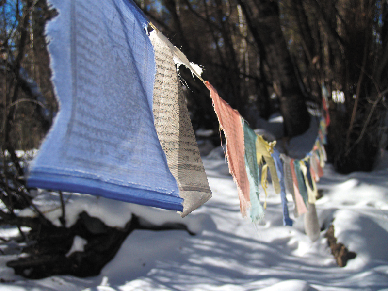
Trails.com rates Cottonwood Creek Trail as strenuous, as it does become rather steep at times, and the elevation gain from the trailhead to Broken Hand Pass (12,900 feet) is approximately 5,000 feet and 12 miles round trip. That said, the trail is absolutely worth a visit for even the first couple of miles, particularly if you begin the hike by paying a meditative visit to the makeshift Buddhist shrine erected on the banks of Cottonwood Creek just before the trailhead.
Users are encouraged to practice strict Leave No Trace ethics along the trail, as Cottonwood Creek is a key headspring for local drinking water. Camping is not allowed at the trailhead, but this lightly-traveled trail is a fabulous jumping off point for backpacking escapades up to Cottonwood Lake or South Colony Lakes and the technical climbs of Crestone Peak (14,294’), Crestone Needle (14,197’) and Broken Hand Peak or “Crestolita” (13,573’) within the designated wilderness area.
Getting there: From CO 17, running north-south between Villa Grove and Alamosa, turn west onto County Road T. Upon arriving in the town of Crestone, take a right turn onto Camino Baca Grande. Follow it to the dirt road marked Dreamway and travel along this road roughly six miles, watching for the Cottonwood Creek Trailhead on the left side of the road. ?
Logophile Ericka Kastner finds herself extraordinarily lucky to be paid to write about the places that she loves in the Colorado wilderness. View more of her work online at erickakastner.com.