By Mike Rosso
Back in 1880, a Salida resident named Tom Cooke was searching for horses in the northwest mountains of the San Luis Valley. Instead, he found ore deposits which quickly gained interest from outsiders and within a year, the town of Bonanza City was founded and counted between 1,000 and 1,500 residents by 1882. (At the time, the population of mining towns was determined by the number of saloons and dance halls instead of a census taker).
At its peak, the town had a newspaper, four smelters, two hotels, 36 saloons and seven dance halls (dancing and drinking seemed to be quite the priority with these early Colorado mining-types).
Ore was reportedly discovered at the outcrop of the Rawley Vein, located in Rawley Gulch, in 1880 and significant production of ore from the Rawley Mine began in 1902. The Rawley Mill was completed in 1923 and an estimated 476,000 tons of ore was produced from the Rawley Mine from 1923 to 1930. By 1937, most of the mines in the vicinity were almost played out and a fire that year took out much of what remained of the town, which by then was just called Bonanza. Mining did continue sporadically until it finally ceased in 1970.
The 2010 United States Census (not a survey of saloons), showed a town population of 16, which ranked Bonanza as the second least populous municipality in the state of Colorado.
In 2013, the Saguache County commissioners petitioned to have the town disincorporated, as the year-round population dropped to one, Mark Perkovich, who still resides there. Nearby residents objected and the Colorado secretary of state ruled that Bonanza met the legal requirements to remain incorporated.
The term Bonanza has Spanish roots and is defined as “an exceptionally large and rich mineral deposit” by Webster’s dictionary, but after the mines played out, the district became a Superfund cleanup site. To accommodate the tailings resulting from the processing of the large volume of ore from the Rawley Mine, a dam was built across Squirrel Creek below the mill. An additional three tailings dams were constructed on Kerber Creek below the town between 1925 and 1930.
In September 1994, American Smelting and Refining Company (ASARCO), initiated the removal of the Rawley Mill tailings from Squirrel Creek. An estimated 31,000 cubic yards of tailings were excavated from Squirrel Creek and disposed of at an on-site engineered repository at the middle tailings dam below the town. An additional 85,000 cubic yards of tailings were excavated from the upper and lower tailings dams and consolidated at the repository in 1995. The same year, ASARCO reclaimed the area, incorporating the upper tailings dam. In 1996, ASARCO reconstructed and reclaimed the stream reach of the Squirrel Creek channel that was impacted by the Rawley Mill tailings. In 1997, restoration activities occurred along the riparian corridor of Kerber Creek and by 1999, the cleanup was completed and a residential soil sampling investigation in the town determined the concentrations of lead weren’t significant with respect to human health. The U.S. Environmental Protection Agency agreed with these results and no further action was deemed necessary.
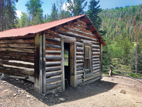
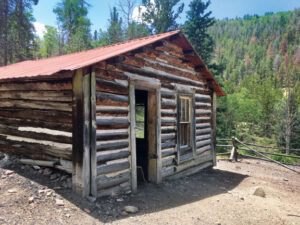
On a recent visit, the town is showing more signs of life than for many years. Seasonal residents have restored old cabins and are building new ones and the area is very popular with ATV and OTV users due to the nearby La Garita trail system to the south and other jeep trails found nearby such as Brewery Creek and Slaughterhouse Gulch. There is an old cabin and cemetery at the town site of Exchequer, which was formed in the 1860s, just on the outskirts of Bonanza. The Exchequer Mine was a silver, copper, and gold mine located at 9,839 feet. The town of Bonanza sits at 9,478 feet.
Remains of some of the mines can be found above the town on County Road LL56 (four-wheel drive is recommended for venturing beyond town limits) and throughout the district. If you visit, please don’t disturb any old mining artifacts or the residents of the town, for that matter.
GETTING THERE: From Poncha Springs (4WD only)—Take U.S. Hwy. 285 south from Poncha Springs. Turn right (west) onto County Road 47YY at Mears Junction. Follow this for nearly 22 miles to the town site.
From Villa Grove 2WD—Head north on U.S. 285 from town and take a left (west) in a quarter mile on County Rd LL56. Follow this for just over 14 miles to the townsite. The drive along the Kerber Creek valley is quite scenic and if you are in need of a leg stretch either coming or going, the Soda Springs Trail, an up-and-back hike, can be accessed on the north side of the road about halfway to Bonanza from U.S. Hwy. 285. Look for the interpretive sign.
The Places column is sponsored by Mark Zander and Leslie Champ.