Article and photos by Chas S. Clifton
Wildfire – July 2000 – Colorado Central Magazine
DESERTED MUCH OF THE TIME, the old Wetmore school’s parking lot was filled one night in October 1999. The big basement room — the lunchroom in former days before consolidation with the Florence school district — was packed with eastern Custer County residents, and volunteers were carrying in more folding chairs from the storerooms.
Tonight’s topic was forest fires, and residents were about to be introduced to a startling piece of news. Instead of automatically putting out forest fires, the Forest Service wanted to start some — all around their homes.
Eight “prescribed” forest fires were planned for the forest east, west, and south of Wetmore.

These Custer County residents were meeting the new face of national forest management, one that has grown in recent years in contrast with the post-World War II philosophy of “fight every fire.”
When the Forest Service was young, early in the twentieth century, forest fires were fought more leisurely if at all. Fire crews consisted mainly of whoever was around at the time: ranchers, loggers, even unemployed men hired by the day.
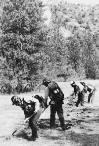
Forest Service crew members complete a fire line as smoke rises behind them from the controlled burn.
After World War II, a New Mexico bear cub was canonized as “Smokey Bear,” patron of firefighters. New tools — parachutes, slurry bombers, walkie-talkies — and a new scientific attitude all contributed to a paramilitary approach to firefighting. The nation needed houses and every tree saved was — in theory — a board for the lumber yard.

Fifty years later a reassessment has begun. Government news releases, like this one from the City of Boulder, now praise the wildfires of old: “quick, low-intensity fires [that] cleansed the grassland and forest floor of ground litter, returning important nutrients back into the soil under the heat-absorbing, blackened earth. This process enriches and stimulates the ground for the following growing season, providing valuable forage for wildlife. Through prescribed burns, fire managers can safely reintroduce fire into the ecosystem to provide native plant and wildlife support. Prescribed burns may also help suppress nonnative species that threaten our landscapes and reduce fuel buildup that can lead to devastating wildfires.”
Central Colorado’s prescribed burns have thus far pretty much stuck to plan, but when “fire managers re-introduce fire into the ecosystem,” unplanned events can occur. In May, a 600-acre prescribed burn at Bandelier National Monument turned into the largest wildfire in New Mexico history. The “Cerro Grande” fire, burned portions of the Los Alamos National Laboratory and the adjacent town of Los Alamos.
Holding a pulaski, a crew members watches the fire to keep it from crossing the line.
In recent years, a fire set to control noxious weeds near Lewiston, Calif., ended up taking out 23 houses, while a range-improvement burn in the Wind River Range near Pinedale, Wyo., jumped its bounds and covered 4,500 acres in five days. All left legacies of community resentment, and after this May’s Cerro Grande fire, Interior Secretary Bruce Babbitt and Agriculture Secretary Dan Glickman called for a temporary moratorium on prescribed burns. Not to be left out of the rush to “do something,” Colorado Governor Bill Owens announced that he was placing his own moratorium on state air-quality permits, a necessary step of the planning process for a controlled burn.

A writer who had seen and photographed the Lewiston fire commented, “Had this fire been started by lightning instead of drip torches,” the loss of agency credibility would have been replaced by praise for the fire-fighting crews. Biologists who studied the aftermath of the Wyoming burn did report increased use of the “treated” area by deer, elk, and sage grouse.
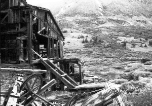
Similar prescribed burns were proposed near Wetmore a decade ago but ran into opposition from the owners of two large properties, the Billington Ranch and the Farley Ranch, on the area’s western edge, where the Forest Service had planned to station crews. The fire plan went on the shelf, and the dense stands of ponderosa pine trees grew thicker. Now, says assistant ranger Mike Smith of the San Carlos Ranger District, “we have a new plan and we can do it without them.”
My neighbor comes to the door collecting donations for the Wetmore Volunteer Fire Department. “We’re against it,” he says of the planned burns — yet, if this plan follows the earlier one the volunteers will have to be on the scene.
Other neighbors worry about smoke inhalation, loss of wildlife, and just the look of blackened forests. In March comes a letter from Forest Service and BLM officials: they will begin with areas farthest from homes and defer until fall 2000 those closest to Wetmore and Colorado Highway 96.
The History of Fire in the Sangres
Unlike the Wet Mountains, the Sangre de Cristo Mountains have been the subject of a formal historic fire study. It is no coincidence that prescribed burning in both the Sangres and Wets began about the time a Ph.D. student in forestry at Colorado State University completed her dissertation.

Titled “Fire History and Landscape Patterns in the Sangre de Cristo Mountains, Colorado,” it represented several summers worth of analysis of both sides of the range by Catherine Alington, a native of New Zealand.
Partly supported by a Forest Service grant, Alington had hiked and mapped six valleys on the Wet Mountain Valley side and three on the San Luis Valley side in order to discover how frequently and how extensively they had burned in the past; and how forest type and altitude influenced fire patterns.
By studying old fire-scarred trees and cutting wedges from their trunks, Alington developed a “fire chronology” for the Sangres. She concentrated on the period before 1910, when forest fires began to be fought more systematically. She identified forest fire dates as long ago as 1478 in some cases, and she was able to calculate numerous fires (and map their approximate extent) from the 18th and 19th centuries.
Between 1860 and 1910, during the period of first Anglo settlement, fire frequency actually increased, as ranchers set fires to increase grass production and prospectors sought to uncover mineral deposits.
Since prevailing winds blow from the west, Alington noted, fires on the western (San Luis Valley) side of the range tended to be larger in the past, while eastern-side fires burned smaller patches and often switched directions, or “walked around” as surface heating created shifting winds.
On the east (Wet Mountain Valley) side, she concluded, the mixed conifer forest (primarily ponderosa pine and white fir) typically burned about every 30 years, while the higher, damper subalpine (spruce-fir) forest averaged 90 years between fires.
Fires on the west side seemed to be fewer but larger, appearing on average every 92-118 years in each valley.
The east side’s mixed-conifer forest, Alington observed, has now gone through two “normal” fire cycles, leading to a situation where “the lack of fire may have created an accumulation of fuel both on the ground and in the standing biomass.”
Alington’s conclusion, while expressed in measured scientific language, supported the concept of prescribed burns. “From a management perspective my results suggest that landscape structure might be manipulated or maintained through disturbance regimes…. Frequent small fires may be a useful tool for land managers as they not only achieve the required results in terms of desirable condition, but they are a manageable option.”
While Catherine Alington was completing her dissertation in Fort Collins, the Forest Service and Bureau of Land Management began planning a prescribed burn south of Cotopaxi in the Sullivan Creek drainage. Partly funded by the Rocky Mountain Elk Foundation, this burn covered 680 acres in several increments during 1998 and 1999. Designed to improve deer and elk forage, the Sullivan Creek burn affected mostly oak brush and dense stands of conifers. The agencies plan eventually to “treat” about 1,200 acres overall.
Introducing Fire to the Wet Mountains
With the same justification of “better big-game winter range” and “reduced fuels,” the Forest Service began its prescribed burns in the Wet Mountains this spring.
The burning started along Middle Red Creek, carried out April 9-12, 2000 in an area southwest of Wetmore and south of Colorado Highway 96.
The time window was narrow: snow had to have melted, but a Forest Service wildlife biologist had asked that no burning be done after mid-April, in order to protect nesting warblers and ovenbirds. (Some owls and other raptors nest earlier; evidently they were on their own.) Most grasses and wildflowers would be dormant.
To prepare, the crew hand-scraped fire lines on the east and west boundaries of the first burn area, about 350-400 acres of south-facing slope, with ponderosa pine lower down and a piñon-juniper mix higher up. An old wagon road formed the lower boundary, and the crew burned along the top edge first to form a charred strip. Some of that fire actually slopped over the ridge line, but no one cared because the other side was scheduled for burning later.
One employee’s job was to sit in his pickup near a “Prescribed Burn in Progress” sign on Colorado 96, ready to answer the public’s questions and relay communications, while another parked on a ridge that gave a general view of the fire area and of a nearby ranch, where a Forest Service fire truck and its crew waited, just in case.
The fire crew’s goal was a fire that crept along about knee high, scorching the skinny stands of “dog hair” pines but leaving the mature trees unaffected. Thickets of Gambel oak would be charred too, although most would eventually come back from their roots. The ideal result would be what foresters like to call a “mosaic”: thick forest broken with small openings.
“I don’t mind blowing out [completely burning] small areas, say four or five acres,” Smith said, “but I don’t want to blow out 300 acres.”
The crews hike in from either side of the burn area, review everyone’s duties, and establish radio frequencies. That done, fire planner Toni Toelle grins and says, “Let’s burn trees.”
But the trees do not always burn, and that is the plan. A slice at a time, like cutting a loaf of bread, the ignition crew sets the fires. They carry drip torches, spouted metal canisters that dribble a 3:1 diesel fuel-gasoline mixture, kept burning by a wick at the tip, onto the forest floor.
The flames creep along in the fallen needles and leaf litter, and the crew members step back and forth over them. Now and again the aromatic oils in a small juniper ignite and it burns, yet, paradoxically, with everyone watching, two larger junipers stand untouched as the smoke swirls around them. In a gully, the flames get more draft and start to roar. Fire climbs another juniper like a ladder and crosses to a medium-size ponderosa, which begins to fly orange flags of its own, but the light breeze and early-morning humidity are enough that the fire does not “crown,” or begin spreading from treetop to treetop.
“Future woodpecker habitat,” says an observer watching the ponderosa in flames.
Members of the ignition crew light oak brush.
White smoke rolls up the ridge, turning brownish-black when a larger tree or cluster of them do catch fire. A 40% loss of conifers would be acceptable, Smith says, but it’s clear not that many big trees are burning. Most of the fire ambles along, feeding on dead twigs, plants, brush. Other crew members patrol the boundaries, making sure the fire does not cross the lines.
The ignition crew, working in the smoke, chatter on their radios, making sure that they don’t accidentally start new fires below each other.
“Come up that little ridge and bring fire with you,” crackles one radio, and I briefly think of the prehistoric people of the 1981 movie Quest for Fire with their precious embers. You could translate that sentence into Neanderthal — if anyone knew how to speak Neanderthal.
Just yards from the fire, chickadees call and flit through the trees. No one I speak to claims to have seen panicked deer or bears on the run from the fire. Maybe they had enough warning. And the burned areas, which remain largely snow-free in the winter, should offer good habitat for deer, elk, and turkeys.
On the following day, the fire expanded — according to plan. About 2,000 more acres on a north-facing slope were ignited by ground crews and a helicopter, which drops a civilian version of napalm. Southwesterly winds pushed the smoke over Pueblo and Colorado Springs, bringing the fire to the attention of television news crews. (A wildfire at the Sand Dunes National Monument contributed more smoke.) Follow-up burns are planned between 2001 and 2003.
As the Red Creek prescribed burn grew, I stood outside my home looking straight up. A westerly wind pushed the smoke up in a wall directly above me; when it faltered, the air turned thick and gray. One burn down — seven to go?
Living with Fire
Critics of the public-lands agencies’ new fondness for fire come from various directions. Some decry what they believe is waste of usable timber, although dense stands of three-inch diameter pine (typical of some Wet Mountains sites) has little commercial timber. Some usable trees will be burned undoubtedly, although I would question whether they are in areas suited for logging to begin with.
Others object on æsthetic grounds, not wishing to view blackened hillsides from their homes. The Forest Service and Bureau of Land Management say they will offer post-fire tours of some of the burnt areas after regeneration has begun, in order to quiet their fears.
Fire climbs from a juniper into a ponderosa.
Air quality is another factor. When the Pueblo or Colorado Springs sky turns yellow, it’s noticeable. California has experienced bureaucratic collisions between environmental protection and forest health. So far, getting a permit from Colorado air-quality authorities has been fairly easy. That could change, but meanwhile, the agencies hope that the public will live with it for the sake of healthier forests. (During the Red Creek burn, one nearby family with an asthma sufferer was put up at a Cañon City motel at government expense.)
A more considered objection comes from Michael Soulé, a Western Slope resident who formerly taught environmental studies at the University of California-Santa Cruz and who co-founded the Society for Conservation Biology.
While agreeing that fire can help protect biological diversity in large areas of unbroken habitat, 50 to 100 times the size of the fire, Soulé fears that disturbing smaller areas with fire could speed up species loss. Setting a series of fires in a relatively small area, as called for in the Forest Service’s plan for the Wetmore area, could be counterproductive even while justified as benefiting wildlife.
Historians and geographers know that much of the American landscape — even the Eastern woodlands that the first Europeans saw — was shaped by fire. American Indians set fires to open up land for hunting and farming, entice buffalo to fresh grass, and even to make their living areas less buggy.
Now, after fifty years of aggressive fire control, prescribed burning is touted as the cure for ailing forests. Despite disasters like the Los Alamos/Cerro Grande fire, forest managers will continue to recommend it, saying they have learned from others’ mistakes. Given the likelihood of more “urban interface” political conflicts over burning in the future, we are probably entering at least a short-term era of enthusiastic prescribed burning — while it’s still politically possible.
Chas S. Clifton lives in eastern Custer County. He teaches writing at the University of Southern Colorado in Pueblo.