
Brief by Central Staff
Transportation – May 2000 – Colorado Central Magazine
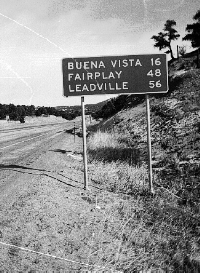
After the Colorado Department of Transportation overhauled the intersection of U.S. 285 and Colo. 291 north of Salida last year, a new sign went up pronouncing LEADVILLE 56.

According to the official state highway map, it is 60 miles from Salida to Leadville, and Colo. 291 extends for 9 miles from Salida to the junction, so Leadville should be 51 miles from the junction. Where did the extra five miles come from? Has Leadville entered some cosmic vortex where the normal rules of geometry no longer apply?
We have observed before that the distance between Salida and Gunnison (71 miles) differs from the distance between Gunnison and Salida (66 miles), if you go by the signs posted by the Colorado Department of Transportation. A similar anomaly holds for the distance between Gunnison and Alamosa via North Cochetopa Pass.
Perhaps the best course is to ignore those posted distances, and figure that you’ll get there you when you get there.