

In part one of this series last month, we introduced the effort by Hannes Zacharias of Lexana, Kansas, to follow a drop of water from the headwaters of the Arkansas River in Colorado to the Gulf of Mexico. He is making the trip mostly by kayak, but as you’ll read in the following account, he’s not averse to employing other means of transportation, including horses. – Mike Rosso
Since my last report, I have seen the Arkansas River swell in abundance and then disappear into the Kansas prairie, only to re-emerge and grow into a large transportation corridor.
I am currently in Webbers Falls, Oklahoma, some 20 miles east of Muskogee on the Arkansas. The river here is deep and broad, with a minimum of nine feet in the channel to accommodate barges ferrying fertilizer, grain, and raw material for manufacturing to and from the port of Catoosa and Muskogee.
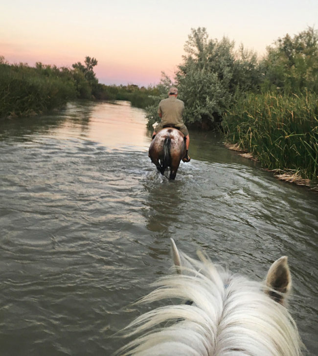
Taking up where we left off a month ago, I was able to paddle the river from eastern Colorado into western Kansas by virtue of Kansas calling upon its portion of water from the John Martin Reservoir near Fort Lyon. Camping out below the dam following my paddling across the reservoir, I was disappointed to see virtually no water being discharged from the reservoir thus halting my trip. To my delight the next morning, the discharge rate went from 100 CFS (cubic feet per second) to 1,300 CFS. This created a flood of water I could ride across the Kansas border. This amount of water yielded the exact amount negotiated with Colorado to cross the Kansas border. But for the occasional barbed and electric wires crossing the river in Eastern Colorado, I was able to paddle all the way to Kendall, Kansas. There, irrigation takes over once again, harvesting 100 percent of the Arkansas River water for diversion to get irrigation channels. This made paddling impossible since 100 percent of the water is taken for such purposes at Deerfield, Kansas just west of Garden City. As a result, I had to find other means of exploring the river. I was able to hike small portions of the river sand bed, explored it on horseback, and traversed it on an all-terrain vehicle for some 65 miles. At one point, I was able to go back upriver and ride a horse in the water, occasionally swimming with it through the deeper portions. This was a thrill, even for a person growing up in Dodge City. One of the more unusual ways of transporting my kayak, was by Conestoga wagon through the streets of Dodge City, an unusual sight to be sure.
[InContentAdTwo]
Obviously, where the river bed is dry, vegetation is sparse and very much like the surrounding prairie itself. What was interesting, however, is that in the area just east of Dodge City, portions of the Ogallala aquifer start seeping up into the riverbed, creating an oasis with pools of water supporting a wide variety of aquatic life and varied vegetation, including fruiting mulberry trees, which bore succulent, ripe black berries that we harvested with great relish. As the riverbed moves north to Great Bend and then south east again to Hutchinson, numerous cottonwoods and other prairie foliage come into existence. River flow begins again around Hutchinson to the point where private vendors rent kayaks for three-hour excursions through the community. I had the opportunity to kayak with a dozen other folks from Hutchinson though this area. They were thoroughly enjoying themselves in the river.
In Wichita, I abandoned my vehicle and since then I have been totally reliant upon my kayak. The river here in Wichita is braided and broad. As a result, periods of flow are followed by periods of long sand bars and dragging on the kayak. The landscape is lush with many water fowl and birds of prey, including eagles. But, this method of floating and dragging is wearing on my body.
It is interesting that people are following my journey with great interest, to the point where they are corresponding with me to join in. In one instance, a group of four gentleman wanted to kayak with me in Arkansas City. We did so, following the river at a leisurely pace, coming to locations where archaeological digs are being conducted near the confluence of the Walnut and the Arkansas Rivers. At this location it is believed that a community of 20,000 or more Native Americans lived and exchanged in a battle with the Conquistadors coming north looking for the lost city of gold. Innumerable arrowheads have been found on this sandbar of these two rivers. It was fun to swim and play in the water with this group, and to be hosted by them for dinner and a place to stay in their charming makeshift riverside shack.
The braided river continued through the crossing into Oklahoma where the river feeds the large Kaw Lake just north east of Ponca City, Oklahoma. Unfortunately, the dam releases virtually no water to the Arkansas. Other tributaries downriver from this point recharge the Arkansas River and provide the flow into the Keystone Reservoir just north of Tulsa, Oklahoma. Again, no appreciable amount of water is released from Keystone, except for the surge of water coursing through the dam to generate power for thirsty air conditioning units. As a result, I opted to portage my kayak over to the Tulsa Port of Catoosa, the furthest inland port on the Arkansas River, where water is more plentiful in the regulated channel. I have been following this course of water for the last several days, no more dragging.
Issues with my travel now involve water with no current, paddling in high temperatures and dealing with high humidity. Dangerous conditions for a person of my age or anyone doing physical activity in the heat of the day.
Currently, I am making about 20 miles per day traveling in the cool of the morning, holding my progress to avoid the peak of the afternoon heat, and proceeding on into the late afternoon to complete the required miles. Barge traffic is allowed on this portion of the river, however I’ve seen little activity to this point. The shoreline is dotted with the occasional towboat and barge waiting for unloading or loading, depending on what the situation calls for. This area requires me to go through one of the 18 locks and dams on the river. Locking through was an experience in and of itself, but with preparation and experience, a fairly efficient and safe operation.
The public attitude toward the river has changed somewhat from the Colorado/Kansas to the Kansas/Oklahoma portion. For the former portion, it appears to me people are very concerned about the water the Arkansas River brings but little attention to the river itself. For the latter portion, people are very concerned about feeding water into the river to maintain commercial barge traffic, but still little regard is given to the river for it’s aesthetic or recreational value.
This portion of the trip also allows me to compare with my 1976 trip, in which I followed this same journey from Wichita on down to New Orleans. Much of the river is the same as I remember some 42 years ago; lush vegetation, broad river, deep channel. Water is less plentiful now than in 1976, however that was a year which saw significant rain. The people I encounter along the way are similarly hospitable and extremely friendly. Some modest changes are seen, particularly in the way some communities are approaching the river, providing some level of public amenities to increase usage on the river. Of particular note is the investment made by Derby, Kansas, in its riverfront park and of Tulsa, Oklahoma, which is completing a large park on the riverfront called the gathering place. Webbers Falls, where I am currently, has developed a small park with a ramp for boating on the Arkansas. At this point in my journey, I am just a over halfway in terms of distance and two-thirds complete, regarding time. I have some 900 miles to go before I pour out the water I gathered at the Colorado headwaters into the Gulf of Mexico. I am confident that September 1 will see me complete the trip as scheduled.
Hope this will become a Book!