By Jolie Anderson Gallagher
Editor’s note: The following excerpt is the first chapter from a new book: Colorado Forts, published by The History Press, Charleston, SC, ISBN #978.1.60949.660.9.
Contested Borders (1806–1822)
At the turn of the nineteenth century, the fledgling United States hungered for new territory. To the west of the Mississippi lay uncharted and unpopulated terrain of striking contrasts: towering mountain ranges, expansive plains and verdant valleys. Yet that wide swath of land was alternately claimed by the British, Spanish and French. In a political topography defined by competing interests and contested borders, European nations stood in the way of America’s desire to extend its influence across the continent.
Americans eyed the Louisiana Territory, 828,000 square miles stretching from the port of New Orleans up through the Mississippi basin, to the eastern edge of the Rocky Mountains. Spain had claimed that land in 1800 but had agreed to transfer portions to France in a treaty. Their negotiations dragged on for years, and before the two nations could settle the details, an impatient Napoleon Bonaparte slapped a For Sale sign on the territory. Desperate for cash, Napoleon offered it to the United States for a bargain: a mere $15 million (three cents an acre). President Thomas Jefferson readily accepted Napoleon’s offer, effectively doubling the size of the country. In the process, he made an enemy of Spain.
During the confusion of land transfers between Spain, France and the United States, the borders of the Louisiana Territory were not clearly drawn. Spain argued that the land included no more than the western bank of the Mississippi, while the United States claimed it comprised the entire Mississippi watershed, extending as far west as the Continental Divide. In an effort to secure U.S. sovereignty, Jefferson commissioned several expeditions to explore Louisiana. Lewis and Clark first traveled up the Missouri River and over the Rockies, ultimately reaching the Pacific Ocean. The Freeman-Custis team then explored the Red River Basin, seeking a trade route to Santa Fe. Later, the commanding general of the United States Army and new governor of Louisiana, James Wilkinson, ordered an expedition into the southern Rockies.
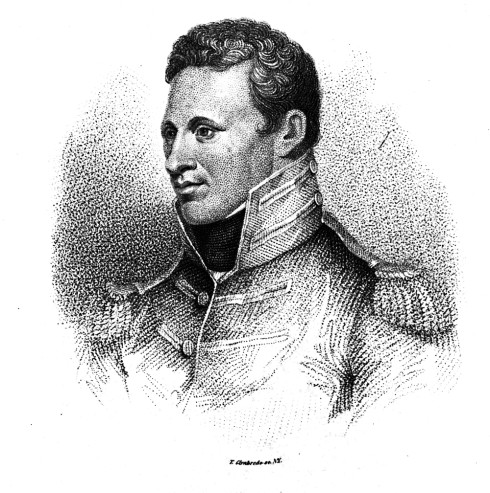
Leading this third expedition was a young lieutenant named Zebulon Pike. Within six months, a vicious winter would force Pike’s team to construct a shelter in the San Luis Valley. His stockade was the first of many forts where Americans would lay claim to the Rocky Mountains and the grassy plains – land that would become the future state of Colorado.
What, Is This Not the Red River?
At age twenty-seven, Pike already proved he could lead successful expeditions up the Mississippi. He was confident that he could chart the Arkansas River into the Rocky Mountains as well and then locate the headwaters of the Red River. The Freeman-Custis expedition had failed to reach the Red’s headwaters when confronted by Spanish troops, forcing the group of scientists to turn around. It then fell on Pike’s shoulders to succeed where Freeman-Custis had failed, and as Pike would soon learn, General Wilkinson had assigned him a near impossible task. The Red River did not flow from the Rocky Mountains as some early maps suggested. Instead, its headwaters rose from the Texas Panhandle. Nor did Pike understand how far his journey would take him. Assuming his expedition would return by early autumn, he and his men dressed only in thin summer uniforms. They neglected to pack coats, woolen socks or extra food.
Joining Pike was a team of nineteen enlisted men, a volunteer doctor named John Robinson and his interpreter Baronet Vasquez – all young men whom Pike affectionately called his “damned rascals.” They began their journey from Fort Bellefontaine, Missouri, in the summer of 1806. First, they escorted a delegation of Osage Indians up the Missouri River and then turned south to the Arkansas River. There his team splintered into two groups. He ordered six soldiers to explore downriver to the east while Pike and the remaining fifteen men traveled west. Along the route, he stumbled upon a trail of beaten-down grass and trash-littered campsites. Pike immediately suspected that Spanish troops planned to intercept them as they had with the Freeman-Custis group. Careful not to overtake the Spaniards, Pike slowly followed their trail into the mountains.
Farther upriver, Pike spotted a large blue cloud to the northwest. Examining it closer with a spyglass, he realized that it wasn’t a cloud at all, but a grand peak looming ominously over the plains. Day by day they marched toward the mountains, never seeming any closer. With their supplies running low and their eastern-bred animals dropping dead from lack of grass, the team finally reached a major tributary flowing into the Arkansas in November (at present-day Pueblo). Needing shelter and food, they made camp along the river and constructed a log blockhouse – possibly the first structure built by white Americans in the region. They cut fourteen logs, stacking them five feet high on three sides, with one side open to the river.
All the while, Pike couldn’t take his eyes off the grand peak. He thought surely they could make a side trip to climb it, a day’s trip at most. With three others, Pike struck out for the blue mountain. The men slogged through deep drifts of snow, only to reach the base two days later. After another hard day of hiking, they ascended a peak to discover a depressing sight. To their dismay, the blue mountain rose above them to the north, at least fifteen miles away. After realizing they had climbed the wrong peak, Pike turned around and grumbled that the blue mountain was impossible to scale. He wrote in his journal: “I believe no human being could have ascended to its pinical [sic].”
Continuing their mission, the men abandoned their log shelter and rode west through icy creeks and snowdrifts. Once they successfully charted the Arkansas River deep into the Rockies, Pike set his sights on the Red River. But to his dismay, creeks and canyons led to dead-ends. Snowstorms blinded him. High canyon walls blocked his view. Completely disoriented, Pike looped back until they reached a former campsite at the base of the Royal Gorge. Only then did Pike realize they had wandered in a wide circle. Defeated, Pike wrote in his journal, “I now felt at considerable loss how to proceed.”
In the crushing grip of winter, the stubborn lieutenant refused to abandon the mission. Until he found the Red River, he could not report back to his commanding officer and mentor, General Wilkinson. No matter what the cost, no matter what pains his men suffered, Pike would keep pushing. Pike ordered the men to build another blockhouse near present-day Cañon City. This time, he told his interpreter Baronet Vasquez and a private to stay behind with the emaciated horses, their dress uniforms and heavier supplies. Turning south, the remaining thirteen men marched on foot through waist-deep snow while carrying seventy-pound packs on their backs. Although they wrapped their feet in shredded bits of blankets inside their boots, the added protection wasn’t enough. Several men had stepped in creek water and walked on ice-encrusted feet, eventually causing them to collapse in agony. Sympathizing but not stopping, Pike left the men where they fell. He provided them with the remainder of their food and then promised to return. The group continued over the Sangre de Cristo Mountains, finding abundant deer to hunt but leaving yet another man behind who could no longer walk.
Over a mountain pass, Pike stumbled into a startling landscape of snow-covered sand dunes and a major river cutting through a broad valley beyond. Encouraged, Pike assumed he had discovered the Red River and marched his men south until they reached it. Up a tributary, he located a grove of cottonwoods they could use for building a stockade, with a steep hill nearby where he could post a sentry. They would need shelter not just for warmth but also for defense. If the Spaniards discovered them, his men might be forced to fight behind its walls.
As the icy winds blasted through the valley, the men piled logs thirty-six feet square and twelve feet high. Inside they dug a shallow ditch along the walls and then planted sharpened stakes to project menacingly over the top. When it was finished, Pike raised the American flag. It’s possible he didn’t realize that they had crossed over the fuzzy boundary of Louisiana Territory. His stockade sat squarely in New Spain.
In any case, Pike had prepared for Spanish visitors. In his journal, he wrote about the fort’s unique method of entry and its defensive attributes:
Our mode of getting in was to crawl over the ditch on a plank, and into a small hole sunk below the level of the work near the river for that purpose. Our port-holes were pierced about eight feet from the ground, and a platform was prepared to shoot from. Thus fortified, I should not have had the least hesitation of putting the 100 Spanish horse[men] at defiance until the first or second night, and then to have made our escape under cover of the darkness; or made a sally and dispersed them, when resting under a full confidence of our being panic-struck by their numbers and force.
When the stockade was complete, Pike ordered a five-man detail to fetch the injured men left in the mountains. At the same time, Pike’s doctor asked for permission to leave the group. Dr. Robinson was anxious to complete some business dealings in Santa Fe to the south. Although some of his men needed medical attention, Pike allowed it. The doctor was a volunteer, not officially under his command. As the doctor walked south, the Pike team continued to fortify the stockade by digging a ditch, four feet wide and two feet deep, around the outer walls. Then they drained river water into the moat. If they were forced to make a stand against the Spaniards, they would need access to water.
The crisp winter days passed peacefully, and the rescue party returned with just one of the injured men. Pike’s corporal reported that the other two could not walk on their frostbitten feet. The corporal then handed Pike a gruesome gift. In a desperate plea not to be forgotten, the crippled men had sliced off their frostbitten toes for Pike to keep as a reminder. Pike was horrified, insisting that of course he would never leave them to die. He wrote, “little did they know my heart, if they could suspect me of conduct so ungenerous.” Immediately, Pike ordered another detail to retrieve the men and horses at the Arkansas shelter and then swing back to rescue the disabled boys.
Pike saw no signs of Spaniards until mid-February 1807. While he was out hunting, the sound of his gunshots echoed through the valley and revealed his location to two riders nearby. Pike remained calm as a Spaniard and his Indian scout approached. He greeted them and played innocent, claiming that he was on a hunting excursion. But the Spaniard wasn’t fooled. He said they had met Dr. Robinson in Santa Fe, an encounter that aroused their suspicions that more Americans had entered their territory. The Spaniard tried to wrangle as much information from Pike as possible. How many men did he have? Where were his horses? Why was he here? Pike knew he couldn’t shake him. He invited the Spaniard and Indian scout back to the stockade, offered them food and tried to answer their questions politely without revealing details of their expedition. When finally they left, Pike knew more Spaniards would come calling.
A week later, Pike’s hilltop sentry alerted them to riders approaching the stockade. Two Spanish lieutenants from an advance guard cordially greeted Pike. They wanted to question him. Pike complied, inviting the officers inside the stockade for breakfast. As he motioned toward a small hole dug under the logs, the Spaniards looked at him strangely – was that the only entrance? Grudgingly, they followed Pike by crawling on all fours over the plank, then scooting on their bellies through the opening. Once inside, the officers dusted off their fine uniforms and asked Pike why he had entered Spanish territory. Pike insisted he only sought the Red River, part of the United States. The Spaniards shook their heads, informing Pike that he was mistaken in his geography. Pike interrupted them. “What … is not this the Red River?” he asked. The officers told him that no, he was on the Conejos River, a tributary of the Rio Grande. He had missed the Red River by five hundred miles.
Outside, Spanish soldiers surrounded the stockade. Pike crawled out and ordered his men to lower the American flag. The Spanish officers insisted on escorting them to Santa Fe, mildly promising not to take them prisoner because their countries were not officially at war. Pike said he would go nowhere until his entire team regrouped. He explained that two of his men lay injured in the mountains, two remained on the Arkansas with their horses and another two had marched out to retrieve the others. After a heated exchange, the Spanish officers finally agreed to round up all six men. Pike wrote:
My compliance seemed to spread general joy through their party, as soon as it was communicated; but it appeared to be different with my men, who wished to have “a little dust,” as they expressed themselves, and were likewise fearful of treachery.
Pike told his men to pack their belongings and go quietly. After the journey south with the Spanish cavalry, Pike’s team presented a sorry sight in the bustling village of Santa Fe. Wearing only tattered clothes, their coarse appearance mortified Pike, particularly when the villagers asked if all Americans lived in camps like Indians. Despite their ragged attire, the Spanish governor of New Mexico, Joaquin Alencaster, treated them to elegant dinners, fine wines and fandangos with ladies of the night. Meanwhile, the two Spanish lieutenants kept their promise and sent patrols to retrieve all his men left behind. The crippled soldiers received medical attention in Santa Fe, although they would never walk again.
As the Americans recuperated, the governor told Pike that the commandant general of the Internal Provinces, Nemesio Salcedo, wanted to question him further in Chihuahua. His escort would be Lieutenant Facundo Melgares, the commander who had led his forces the previous autumn in a failed attempt to intercept Pike. Possibly annoyed that Pike had eluded him, Melgares was at first aloof with Pike and told him he could not take notes while in Spanish territory. The request didn’t faze Pike. On the long trek to Chihuahua, Pike pretended to have stomach troubles. He made frequent visits to the bushes and frantically wrote in notebooks, reporting on Spanish forces and the terrain, information that could prove valuable to his commander. At night, he rolled up his journals and stuffed them down the barrels of their empty firearms. If Melgares noticed, he looked the other way. Over the weeks, Melgares had slowly warmed to the American officer, a man much like himself. When Melgares and Pike finally parted ways, they pledged their friendship and hoped to meet again under better circumstances.
In Chihuahua, Pike submitted to more questioning at military headquarters. After the meeting, the Spaniards had no reason to detain him further. They eventually escorted him back to the American border in July 1807, one year after his team departed. After such an important expedition, he assumed he would receive a hero’s welcome like Lewis and Clark before him. Instead, he received the cold shoulder from St. Louis citizens. While Pike was gone, American gazettes had buzzed with news of a growing scandal that involved Pike’s commander. General Wilkinson was suspected of plotting to create a new empire southwest of the Mississippi, an isolated territory that he planned to govern with the former vice president, Aaron Burr. Although Burr was arrested and put on trial, there was no direct evidence to convict him, nor could anyone establish Wilkinson’s involvement. Not until a full century after his death did Spanish documents surface that proved he was a double agent. Wilkinson had tipped off Spain about the Freeman-Custis expedition and the Pike expedition as well.
To this day, historians still argue over the role Pike may have played in the Burr-Wilkinson scandal. Was he a spy for Wilkinson? Or was he an innocent explorer? There is no doubt that his detailed journals enlightened eastern Americans about the Southwest and helped pave the way for ongoing exploration and development of trade routes into Santa Fe, but in his lifetime, Pike never received the credit he was due. Ironically, Pike’s name would become synonymous with the grand peak he never scaled. Almost fifteen years after he tried to climb it, members of the Stephen Long expedition reached the pinnacle. They named it James Peak for Dr. Edwin James, the first white American to set foot on its summit. Stubbornly, mountain trappers called the blue mountain “Pikes Peak,” refusing to acknowledge Dr. James.
As for Pike’s stockade, the logs decayed and washed away in the Conejos River. Through Pike’s detailed notes, pioneers and historians identified its location in 1910. Evidence of a man-made ditch still remained along the river. To preserve the site, the State of Colorado purchased land around the foundation in 1925. Then in 1952, the Colorado Historical Society reconstructed the stockade, which is now a National Historic Landmark and open to visitors in summer.
From the Heads of Spaniards
By 1818, the New Mexico province needed a new governor. Facundo Melgares, the man who escorted Pike to Chihuahua, was Spain’s choice for filling the position. As a seasoned military officer, Melgares had defended Spain against both Americans and Indians and suppressed local uprisings as well. At the time, Spain prohibited New Mexican citizens from doing business with outsiders. As governor, Melgares would guard the passes and trails against American interlopers seeking trade opportunities. However, Melgares had only a handful of experienced regulars at his service, along with a poorly trained local militia. Their reconnaissance missions were ineffective in protecting the main routes into Santa Fe.
In the spring of 1819, Melgares ordered a defensive fort built along the Old Taos Trail, on the eastern edge of the Sangre de Cristo Mountains. The fort was a small, 120-square-foot structure of stone and logs, with a garrison ranging from six to several dozen soldiers. Just six months after the fort’s construction, one of its soldiers stumbled into Santa Fe. Weak and wild-eyed, the man reported that the fort had been attacked by Indians, or maybe men dressed as Indians, he couldn’t be sure. He described to Melgares how he and fellow soldiers had fought valiantly for hours. After their ammunition was spent, the Indians moved in for the kill. All his comrades lay dead on the mountainside. Only he had escaped.
Furious, Melgares immediately sent three hundred men to chase down the culprits. When the troops arrived at the fort, they found the bodies of their fellow soldiers, scalped and stripped. They buried their dead and then scoured the mountains and plains for hundreds of miles. They found no trace of Indians or Americans.
The fort’s attackers remained a mystery for another year until the Stephen Long expedition visited a Pawnee village on the Missouri River in 1820. There, the warriors bragged about a recent raid they made into Spanish territory. They pointed to a pile of booty from the attack, including Spanish clothes and silver coins. The Long team also noticed fine horses grazing around the village, many with Spanish brands. The expedition’s doctor, Edwin James, wrote about the scalps the Pawnee showed them:
I thought that some of the hair which streamed in the wind from numerous portions of human scalps, suspended on sticks from the roofs of the lodges, was taken from the heads of Spaniards.
The Spanish fort remained garrisoned until 1821, after the United States and Spain had finally settled their border dispute. In the Adams-Onis Treaty, the two countries agreed on a dividing line that sliced through the future state of Colorado, running east–west along the Arkansas River and then cutting north from its headwaters to the forty-second parallel. Not long after, the Spanish crown formally recognized Mexico’s independence. Melgares, forced to step down from office, was the last Spanish governor to rule over future Colorado land.
With the contested border between America and Mexico finally resolved, the fort lay abandoned. Over the years, travelers camped by its ruins, until its logs and stones scattered into history. Although the exact site is not known, nor Spain’s name for the fort, Spanish documents and travelers’ journals point to a location five miles down the eastern side of La Veta Pass, on a grassy hill above Oak Creek. In the 1930s, historians located a quadrangle of stones on private property that mark what appear to be the outer walls. Although they found no artifacts, they noticed shallow holes dug all around the site, indicating that treasure seekers may have extracted evidence of what became known in Colorado as “the Spanish fort.”
Colorado Forts, Historic Outposts on the Wild Frontier is available at: Boulder History Museum, City of Greeley Museum, Colorado Springs Frontier Museum, Fort Garland Museum, Fort Vasquez Museum, Fort Sedgwick Historical Society, Longmont Museum and Cultural Center, Old Colorado City Historical Society, The Book Haven, The Bookery, Francisco Fort Museum, West Side Books, Western National Parks Association (various national parks), amazon.com and www.historypress.net.