By Virginia Simmons
The story of this mountain pass really begins a few hundred years before any Europeans entered North America. Until the U.S. Government and pioneers pushed the Ute Tribe onto the reservations on the Western Slope in 1868, the nomadic Ute Indian hunter-gatherers of the Tabeguache Band often used this route as they roamed from the Uncompahgre Valley to the Arkansas River Valley and beyond. The title of Marshall Pass appeared after a crossing in the autumn of 1873 by Lieutenant William Louis Marshall.
He was in charge of a survey party that had been mapping in the San Juans around today’s Silverton. Marshall’s was one division in the U.S. Army Corps of Engineers’ Wheeler Survey of 1872-1879, mapping the vast lands, eight inches to one inch, west of the One Hundredth Meridian. Its supervisor was First Lieutenant George M. Wheeler, who in 1874, led a division across Sangre de Cristo Pass into the San Luis Valley and surveyed the remarkable geologic formations that bear his name, Wheeler Geologic Area.
In early autumn of 1873, at the close of the field season, Marshall’s team had headed northeastward toward Denver from the San Juans. Their route was by way of Cinnamon Pass, Lake City, the Gunnison River drainage and the loop swinging south around the Cochetopa Hills into the northern part of the San Luis Valley, over Poncha Pass, and thus into the Arkansas River drainage and eventually to Denver. The leader was suffering from a history-making toothache, though. As the survey party, with its wagons and mules, approached the area near old Cochetopa Pass, he decided that he needed to take a faster shortcut to the dentist. With one of the survey’s hunters, Dave Mear (no relation to Otto Mears) and a pack mule, the two mounted up and headed for a high gap that he could see on the Continental Divide, which, in fact, was the old Ute trail.
Although Marshall’s mouth was so swollen that he could not eat solid foods, he was making geographic notes and sketches as he rode. At the top, where they laid over for a day, allowing Dave to stir up some gruel, the lieutenant surveyed the pass. His notes were so accurate that subsequently the railroad builders could recognize locations.
In 1873, Marshall was a strapping 27-year-old, hardened by outdoor work. After serving as a youth in the Union Army, he graduated from West Point and joined the Army’s Corp of Engineers, eventually becoming the Corps’ portly chief engineer and a brigadier general. Upon retirement in 1910, with his girth rivaling that of President William Howard Taft, Marshall was appointed by Taft as a consultant on hydroelectric power projects for the U.S. Bureau of Reclamation.
Anecdotes include an underling’s rejecting his request for a D&RG pass over Marshall Pass during his honeymoon in 1884, but in 1910 he rode across it in a special car. In 1909 President Taft also provided ballast in a special train en route to the opening of the Gunnison Tunnel.
Before Marshall with his historic toothache came into the region, Sawatch’s enterprising merchant Otto Mears had obtained a charter in 1869 across Poncha Pass. Next, with Gunnison country’s ranches and mines developing, Mears chartered a toll road in 1877 from Poncha Pass across Marshall Pass, and opened it officially in 1880, when a Barlow and Sanderson stage coach carried former President Ulysses Grant over it to take a look at the Gunnison area’s coal mines.
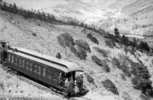
Meanwhile, in 1880, the narrow-gauge Denver and Rio Grande Railway was ready to seize the area’s transportation. Having completed construction of its Royal Gorge route to Salida in May, the D&RG hurried to extend tracks north to booming Leadville and next to Gunnison country, western Colorado, and, importantly, Utah. But, first, the toll road had to be bought from the sagacious Mears. Meanwhile, a competitor, the Denver, South Park and Pacific, was digging a tunnel under the Continental Divide, between Nathrop and Pitkin. By fall, the D&RG consummated the hard-won purchase from Mears, and immediately put 500 men to work spanning the Arkansas with a bridge at Salida and grading up Poncha Pass. The next year, the line was rapidly constructing its trestles and passing tracks, turntables and snowsheds, water tanks and O’Haver Lake to deliver water for the steam engines’ boilers. Amazingly, the D&RG’s first train reached Gunnison by August, winning the contest with the DSP&P. The D&RG’s Gunnison Division continued to operate this route from 1881 until 1955, when service ended and tracks were pulled up.
The distance from Salida to Gunnison was 74 miles, and from Mears Junction to Sargent’s, was 34.2 miles, with the pass’s summit a little over 20 miles from Mears Junction. The west side’s steeper 12.7 miles suffered several wrecks and washouts. When completed, Poncha Pass would have Mears Station on the east and Sargents on the west with an eating house, coal chutes and other facilities. Between were a section house at Gray’s Siding, an enormous snowshed at Shawano Loop, and structures at Chester and Buxton where the grade eased. At the summit, the complex included the station, turntable and roundhouse with shop, snowshed, water tank, two section houses, and from 1919 to 1953 a post office where passengers could mail postcards from 10,842 feet above sea level, the highest post office in the nation. During long intervals between trains, the postmaster/raconteur Gus Latham enjoyed corresponding with former passengers and writing historical booklets.
For a comprehensive history, read Walter R. Borneman’s excellent book, “Marshall Pass.” The pass still invites travelers, except when the road is closed to vehicles in winter or is being repaired.
Virginia Simmons is the author of several books about the region, including the Upper Arkansas Valley, the San Luis Valley, South Park, Ute Indians, and other subjects.