Article by Marcia Darnell
Recreation – March 2005 – Colorado Central Magazine
It’s not easy morphing. The Great Sand Dunes National Park has gone from being a national monument, to a park and preserve, to a national park in the last five years. Composed of park, refuge, and private holding, it’s become an amalgam of land, water, sand, flora and fauna, under three management entities — the National Park Service, the U.S. Fish & Wildlife Service, and The Nature Conservancy.
What it becomes next is, in part, up to all of us. The agencies in charge of the land are developing a management plan, a cohesive vision to best protect the natural resources while educating and entertaining the public. The entities are working with one another, and with the public, to develop such a vision, and it’s time for citizen input.
There are four management plans up for public consideration. The plans offer different levels of public access, public education, and preservation.
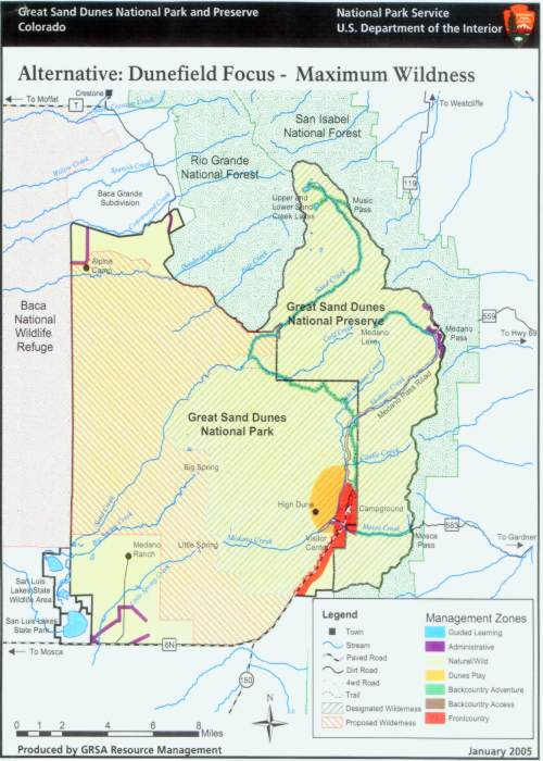
1) Dunefield Focus. This plan offers the maximum wildness of all the plans. Most of the park would be a wilderness area, with administrative areas near the Medano Ranch (southwest corner), Alpine Camp (northwest corner), Medano Pass, and the Visitor Center. There would be no active preservation of structures or archeological sites. Most visitors would play at the main dunes, with no public access to the north end. Facilities at the Dunes would be expanded, but few new trails would be made.
2) Three Public Nodes. More public access would be available, with guided tours and programs at Medano Ranch, backcountry fun around Alpine Camp, and new trails around the Dunes. New trails would be made at Medano Ranch and Alpine Camp, and the Sand Creek and Sand Ramp trails would be connected. No new wilderness areas would be designated, and facilities would not expand.
3) Dispersed Use. This plan would emphasize coöperative use of the area by neighbors such as the U.S. Forest Service and the Baca Wildlife Refuge. More areas would be designated for guided learning and backcountry adventure, with Alpine Camp and Medano Ranch used for administrative purposes. Lots of new trails and trailheads would be built, and possibly a shuttle would take visitors to the Dunes at peak times. Some areas would become wilderness.
4) No Change. The park would remain as is, with no new trails, roads, or programs.
All plans include varying levels of access for hunting, and varying allowances for dogs. Plans for camping facilities are also flexible.
The Dunes management is willing to consider some combination of alternatives, so the plans are not an either/or choice. Public meetings have been held in Alamosa, Crestone, Westcliffe, and Golden to garner public input about the plans.
The Alamosa meeting drew about a dozen people and generated many comments about preservation. Colorado Central contributor Virginia McConnell Simmons expressed concern about protecting the archæological treasures in the park.
(The moderator asked Simmons what kind of measures she’d like to see, and she replied, “Barbed wire.”)
Another attendee was concerned with preserving, if not restoring, the historic buildings there, especially the Medano Ranch house. And one man astutely pointed out that allowing unrestricted hikers into a wilderness area eventually causes more damage than keeping them on marked trails.
The government reps at the meeting also calmed concerns about county finances. Payments in Lieu of Taxes will be made to Saguache and Alamosa counties for five years, and refuge revenue sharing will continue as long as Congress authorizes it.
The Nature Conservancy will continue bison grazing, at least for the time being. Plans for introducing a wild bison herd were scrapped, as was the possibility of opening the park to off-road vehicles on Medano Pass Road.
The Crestone meeting was the biggie, of course, with about 40 people in attendance. The top concern was access to the land. One proposed road to Alpine Camp cuts through the Baca Grande subdivision and is overwhelmingly opposed by Crestone residents. Other possible routes into the northwest part of the park are being weighed, including a road from Hooper.
“People are very interested in mixing and matching the plans,” says Chris Canaly of the SLV Ecosystem Council. The Dunes representatives agree that some further morphing will be necessary to balance access to the land with protection of it.
A plan will be finalized this summer, with the completion of the General Management Plan, Wilderness Study, and Environmental Impact Study slated for next winter. For more info, go to
http://planning.nps.gov/plans.cfm.
Marcia Darnell lives and writes in the San Luis Valley. She enjoys walking and sight-seeing in the Park.