by Tom Karnuta
Part I of this geologic story can be found in the May issue of Colorado Central Magazine. In Part I a brief overview of the geology in the upper section of the Arkansas Valley, from Leadville to Buena Vista, was described and a basic explanation of geologic time discussed.
Driving from the Leadville area downstream towards Buena Vista is a wonderful place to observe some of the most recent changes to the valley caused by the formation, movement and melting of glaciers.
Glaciation in the Upper Arkansas Valley
Glacial characteristics are among the most outstanding topographic features in the upper Arkansas Valley. Glacial cirques and glaciated U-shaped valleys are found in association with many tributary streams and side canyons. Flat, mesa-like terraces and remnants of large moraines add to the upper Arkansas Valley a uniqueness not found along other major streams of the region.
Icecap glaciation – the first of nine glacial episodes in the area – occurred less than two million years ago during the early Pleistocene Epoch. Following this first stage of glaciation the climate began to warm, causing the ice to begin melting. Streams deposited large amounts of coarse gravel (outwash), transforming a hilly, steep topography to a rolling surface of much lower relief. Streams running off the mountains produced broad, gently sloping surfaces (pediments) in the coarse gravel that was deposited across the valley floor.
Large glaciers advancing down the valleys of Lake Creek, Clear Creek and Pine Creek pushed across the axis of the valley, forcing the Arkansas River against the east side of the valley. The Arkansas thus came to be flanked in many places by steadily renewing ice, or moraines, on the west and by hard granite rock on the east. At these places the Arkansas River was forced to cut a new channel, moving eastward until coming in contact with the resistant granite of the Mosquito Range.
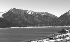
The Lake Creek System (Twin Lakes)

With an overall length of approximately 20 miles and an area of 80 square miles, Lake Creek was the largest of the glacial systems in the upper Arkansas Valley. Ice was supplied to the main trunk of the glacier by 20 tributary or smaller glaciers. The ice within this immense glacier is estimated to be approximately 2,000 feet deep at its thickest point. At maximum extension the ice crossed the valley and pushed into the bank of the Arkansas River. Glacial debris filled the western banks of the river and the river was forced to cut eastward, eventually coming in contact with the Mosquito Mountain Range.
Glaciation of the Lake Creek Valley is directly responsible for the formation of the basins now occupied by Twin Lakes. As the climate warmed and the ice began to recede, its retreat consisted of cyclic alternation of recessions and halts. At the halting places, the ice terminus remained long enough to deposit terminal moraines across the Lake Creek valley. The fist stage of retreat is marked by a moraine that dams the lower, east lake. The current dam we can observe while driving past the lakes is built on this moraine. The second recessional stage is marked by a moraine ridge separating the two lakes. At one time the upper lake had almost as large as area as the lower lake. Subsequent silting has reduced the lake area by more than half. This silting process formed the meadow area above the upper lake by the town of Twin Lakes.