Sidebar by Ed Quillen
Transportation – September 2003 – Colorado Central Magazine
IN GENERAL, the route of the Denver, South Park & Pacific Railroad can be followed today in an automobile, and this time of year, there’s the bonus of the changing aspen.
From the east, Bailey is a good place to start. U.S. 285 comes down Crow Hill into town; the railroad came up the river, and from Bailey west, the railroad grade is often visible as you climb Kenosha Pass. At the top of the pass, the Forest Service has laid a few hundred yards of rail on one leg of the wye where locomotives once turned.
In South Park, the old depot at Jefferson still stands, right next to the road. At Como, where the lines branched, the stone portion of the old roundhouse has been restored, and the railroad hotel stands nearby.
The north branch that gave the South Park its own Leadville connection goes over Boreas Pass — home of some big stands of red aspen. In recent years, the Forest Service has restored several old railroad structures between Como and Breckenridge.
Saturday, Sept. 13 is the 8th annual Railroad Day on Boreas Pass, with tours and historic presentations; to participate, just show up in Como by 8 a.m., and for more information, call the Forest Service at 719-836-3852.
Summit County has changed considerably, so little of the railroad grade remains visible past Breckenridge. Take Highway 9 down to I-70, and go west to Wheeler Junction (known to some moderns as Copper Mountain), then up Colo. 291 to Frémont Pass and Leadville. Some of the old grade is used as a bike trail near the bottom.
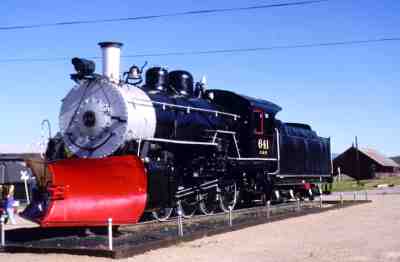
At Climax, the mine is more than obvious, and from there to Leadville, the rails are still in place, hugging the hillside east of the highway (which generally follows the route of the Rio Grande’s line over Fremont Pass). And in Leadville, you can visit the depot on East Seventh Street, take a long look at the steam locomotive, and ride the Leadville, Colorado & Southern Railroad up the hill through the changing aspen on the original South Park grade.

Go back to Como for the other branch. U.S. 285 crosses Red Hill Pass to reach Fairplay. The railroad took a different route, and put Fairplay on a branch line. The South Park City museum has a restored depot and some railroad equipment.
As you head south on U.S. 285, the South Park grade becomes visible again. At the top of Trout Creek Pass, you can see the remnants of a railroad overpass. The standard-gauge Colorado Midland was on top and stays high as you descend the pass. The narrow-gauge South Park ran down near the creek — where it often suffered from floods. Portions of the grade are driveable.
A SPUR LINE from Nathrop served Buena Vista, where the old depot has just been moved to a park next to the highway. The main line went west up Chalk Creek — it joins the road just above the Cascades. From there to St. Elmo, Romley, and Hancock, you’re pretty much on the railroad grade. After Hancock, it’s no longer sensible to drive, but the east portal of the Alpine Tunnel is an easy three-mile walk in good weather.
The tunnel isn’t open. If you want to abuse a 4WD vehicle, you can get to the Gunnison side via Hancock or Williams pass, both rugged, narrow, and steep. If you’re sensible, you reach the west portal from Parlin, about 15 miles east of Gunnison. The Quartz Creek valley is a gorgeous drive from Parlin up to Pitkin (where the old depot still stands) and Ohio City, and finally the west portal of the Alpine Tunnel. Although the road is usually decent (but conditions can change quickly up there), the faint-hearted will not enjoy “the Palisades,” where it is carved from a cliff and supported by immense stone blocks.
This is just a general overview — there’s much more to discover, like the grading toward Kebler Pass northwest of Gunnison, or the spurs and branch lines in the Fairplay area.
–Ed Quillen