
By Ericka Kastner
Some hikes are just worth repeating, and the trek to Mayflower Gulch in the Tenmile Range is absolutely an adventure to revisit time and again. In the summer, the basin is filled with wildflowers, and in the winter, Mayflower is a snowy wonderland for outdoor enthusiasts of all skill levels.
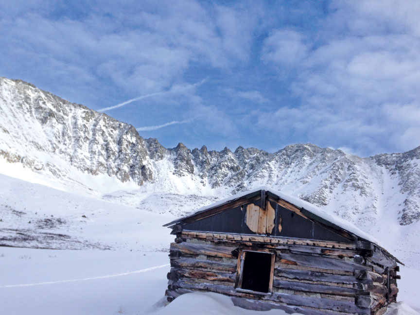
Mayflower Gulch is the site of the historic Boston Mine Camp, which had its heyday back in July of 1884, when a thick vein of gold was found in the Fletcher Mountain basin. Miners quickly realized the vein wasn’t pure, however, and the camp fizzled out. More than 130 years later, the well-preserved cabins are still partially intact and make for a fabulous winter nordic ski or snowshoe to the site, particularly under a full moon.
The old mining road to Mayflower Gulch is accessible approximately 16.5 miles north of Leadville on Hwy. 91. The pullout for parking is on the right side of the road coming from Leadville, and the lot is typically packed on weekends year-round, indicating the popularity of the hike. The best time to visit is early morning on a weekday in winter, where you’ll be more likely to have the route to yourself.

From the parking lot, the moderately difficult, well-marked double track follows the Mayflower Creek drainage at a gradual incline up into the basin. Not far from your start, the trail takes a slight Y to the left; stay to the right on the main road. Along the heavily forested route you’ll find ruins of an old cabin and a mine shaft, making this a terrific hike with young children who need a little something to see to keep their legs moving forward.
[InContentAdTwo]
Approximately 1.6 miles from the trailhead, the view opens up and the Boston Mining Camp becomes clearly visible in the distance. Continue on and take some time to explore the old structures, noting the size of the logs used to create the boardinghouse.
The route starts at 10,996 feet in elevation, and the site of the camp is at 12,415 feet. Intermediate level backcountry skiers may choose to use the trailhead to access routes on Gold Hill or Mayflower Hill. Expert level skiers may prefer to pick lines on the northwest or north-facing slopes of 13,951-foot Fletcher Mountain.
Resource: Making Turns in the Tenmile Mosquito Range by Fritz Sperry
Places columnist and winter lover Ericka Kastner frequently describes Mayflower Gulch as one of the prettiest little spots in Colorado, and she thinks there’s never enough snow where she lives in downtown Salida. View her writing and photography work online at ericka.kastner.com.
What a amazing article Ericka, I was able to experience Mayflower a few weeks ago with the Love of my Life. We frolicked with our snowshoes up to the farthest cabin under the majestic beauty of Mt Fletcher, focused our eyes on some very beautiful scenery and fell in Love with each other once again. Your article brought me back to that unforgettable moment. P.s. Salida doesn’t have enough snowy streets, Cheers
You forgot to mention that a classic, glacial arête is at the head of Mayflower Gulch. A better one cannot be found anywhere else in the state. An arête forms when two cirque head walls are eating up valley from opposite sides of a ridge. In this case, the cirque at the head of McCullough Gulch on the other side of the TenMile Range was eating back toward the one in Mayflower Gulch.