By Linda Gibas
Browns Canyon National Monument is a unique and rugged area which is also Colorado’s newest monument.
Its journey to become a monument began when it was determined by Congress that certain Bureau of Land Managment (BLM) lands had wilderness characteristics. After studying and performing inventories, the BLM concluded in 1980 that 6,614 acres in the Browns Canyon area did qualify for protection as a Wilderness Study Area (WSA). After the WSA was established, numerous efforts were made to protect approximately 22,000 acres as a designated wilderness area, due to the wild and undisturbed nature of the surrounding land. However, numerous efforts to get wilderness protection were unsuccessful in passing through Congress. It wasn’t until Senator Mark Udall introduced a bill to create Browns Canyon National Monument and President Barack Obama signed a proclamation via the Antiquities Act in February of 2015 that we now have Browns Canyon National Monument.
What makes this land so special that people over the years have fought for its protection? Most people experience the monument by rafting through its western border on the Arkansas River. Although this offers an initial introduction to its ruggedness and beauty, it requires heading into the interior to get a much broader scope of what is there. One of the first things you will notice is the solitude that is prevalent. It is removed from the hustle and bustle of the highway running the length of the valley, as well as the very popular river activities. It hasn’t changed much over the years, and is one of few places you can get a glimpse into how wild and remote the entire Upper Arkansas Valley used to be over a century ago. There are incredible rock formations and hoodoos, narrow canyons, beautiful plants and trees, and abundant wildlife. A bonus are the stunning views of the Sawatch Mountain Range towering over the valley.
[InContentAdTwo]
How do you access the remote areas of the monument? The easiest way is to drive to Ruby Mountain Recreation area, continue past the campground and river access parking to the trailhead for the Turret trail/Catkin Gulch Loop. Once you start on the trail heading south, you immediately enter the WSA part of the Monument. If you are hardy enough to go quite a distance, you can hike or ride the trail all the way through the monument to the town of Turret. Part of the trail follows an old road from Turret through the area in the early 1900s terminating at a long-gone bridge across the Arkansas River.
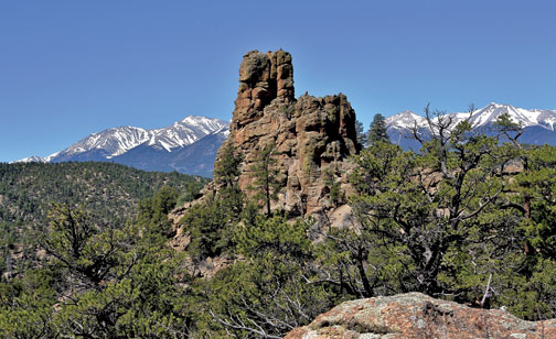
Since the WSA is at a lower elevation than most wilderness areas in Colorado, it is accessible year-round. The more adventurous might head off trail to explore up any of the numerous drainages. Of course, some areas can become impassable, but with the Sawatch Range to the west, it is fairly easy to keep your bearings. As you quietly traverse this land, you might catch a glimpse of some bighorn sheep high up on the rocks, or elk hurrying off into the forest. Perhaps there will be a hawk sending its cries out as it rides the air currents over the landscape or an eagle nesting on the cliffs. If you hike or ride far enough, you will see where a hermit built a primitive cabin sandwiched between two rocks at the base of a large pinnacle rock, and imagine living so remotely with no easy means of obtaining life’s necessities. I often wonder about the past inhabitants of this valley and what they were like. Whether they were Native Americans or early settlers, they came across this spectacular valley and declared it home. It’s up to our generation to see that we protect beautiful places like Browns Canyon so that future generations can enjoy it as well.
To find out more about trails and access to Browns Canyon National Monument, pick up a brochure with a trail map from the National Forest Service Building on U.S. Hwy. 50 east of Salida or visit www.brownscanyon.org.
GETTING THERE: Take U.S. Hwy. 285 to Fisherman’s Bridge/County Road 301 and turn east. Continue up 301 across the Arkansas River and past the Fisherman’s Bridge parking. Turn right on the next road, County Road 300 to Ruby Mountain Recreation Area, bearing right at the Y in the road. This route is passable in a regular vehicle. No ATVs, motorcycles or mountain bikes are allowed in the monument, however there many motorized trails available to ride in the Four Mile Management Area north of the monument and one mountain bike trail in the NE corner of the monument.
Linda Gibas is Board President of Friends of Brown Canyon and is passionate about preserving our public lands.