Sidebar by Marcia Darnell
Sand Dunes – December 2004 – Colorado Central Magazine
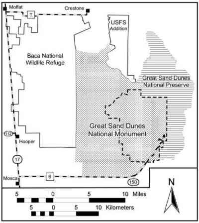
The issue of roads is a hot topic in the West, especially as it pertains to federal lands. Speculation as to whether — and where — new access points will be made to the Dunes has been on the table since the first public meeting about converting the monument to a national park.

Any new road “would be a long time coming,” says Steve Chaney, park superintendent. “It would depend on the outcome of our general management plan and the Fish and Wildlife Service’s general management plan.”
Any new vehicle access couldn’t even begin to be considered until February or March, then there’d have to be several public meetings to discuss alternatives to access. Any roads must be F&WS compliant.
In other words, it’ll take years.
According to Chaney, alternatives include vehicle access to the northwest corner of the park, but it’s unclear how vehicles would get there.
“Perhaps a high-clearance road, or a new road,” says Chaney. “We’ve been openly discussing the possibility of more access to the park from the north. Whether it will be for cars or only foot and horse traffic, we don’t know.”
A further wrinkle in the equation is that there is already one public access route to the northern boundary through the Baca Grande subdivision. However, Baca residents and Saguache County don’t want that to be a publicized route, for lifestyle reasons.
No access from the southeast is realistic . There are over 40,000 acres of designated wilderness there, so people from Colorado Springs will have to travel to the San Luis Valley to visit the park.
Another possible road could run from Mosca or Hooper, but those routes would require lots of improvements, and therefore cost more.
So for now, it’s U.S. 17 to the San Luis Lakes cutoff, or U.S. 160 to the Dunes road. Unless you want to hike in from Westcliffe.