By Hal Walter
Back in the day, my friend Paul and I would head out before light from the BackEdge cabin which he owns at the Gibson Creek Trailhead on the Rainbow Trail. We’d hike northward on the Rainbow in the autumn moonlight reflecting on the skiff of snow, through the big open meadow and then into the forest’s edge, where the moon threw shadows of aspen, pine and fir out onto the blueish-white ground, and just over the low ridge where the rush of Swift Creek filled the air.
The elk grazed the meadows below the valley tree line and returned to their daytime haunts with the rising sun. We would hike, with our rifles and daypacks, keeping our eyes to the ground for the cloven tracks crossing the trail. And when we found them, we would turn uphill to follow the tracks, often tracking all day until the sun would throw the jagged shadow of the mountains onto the valley’s floor, and we knew that descending the fall line from whatever mountain we found ourselves on would bring us back to the trail, True North, and back home.
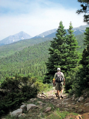
The Rainbow Trail is an oddity among backcountry routes. Running the length of the Sangre de Cristo Range from Music Pass to Poncha Pass, it is both a road to nowhere and the path to everything that this side of the range has to offer. It’s a corridor between private land and wilderness. It is the access trail for most of the high lakes.
The trail is multiple-use, and it’s not uncommon to see hikers, runners, mountain bikers, horseback riders, ATV and motorcycle enthusiasts, and in the winter, snowshoers and cross-country skiers. A segment of the trail was once part of the course for a mountain bike race called the Rainbow Trail Roundup that I rode back in the 1980s, before suspension systems were popular on bicycles.
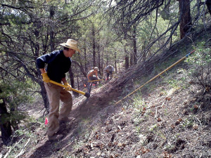
Motorized traffic has contributed to trail damage in some areas. Some sections remain smooth enough to run, but others are so jumbled that walking without turning an ankle can be a challenge. Sometimes I think they should just grade the entire thing into a dirt road and be done with it. I mean, really, once the ATVs are there, what’s the difference?
One of my favorite pack-burro-training runs involves a little-used section of the Rainbow Trail that I have now traveled countless times. I park my truck and trailer at the valley tree line on Hermit Road and jog on over to the Gibson Trailhead, catching the Rainbow Trail southward.
The trail crosses Gibson Creek before rolling through stands of lodgepole, where the path is quite smooth, and then through the aspens where the characteristic Sangre cobblestone litters the trail. The cobble is from the decomposing Crestone Formation sandstone, the reddish sedimentary rock that makes up most of the range. As the rock decomposes, it turns back to sand and releases rounded pebbles of all sizes. No small amount of these stones seem to wind up on the trail in certain areas.
The trail crosses the tiny Verde Creek and then hits the North Taylor Road, which ends above the trailhead to Megan Lake, where the remains of a crashed B-25 still litter the headwall. The Rainbow actually follows this road for a short while before crossing it, dropping down to a bridge over North Taylor Creek, then up and over a ridgeline before hitting Hermit Pass Road. From here, I generally take the road back down to the truck.
Over the years the Rainbow Trail has been a constant in my adventures into the mountains, accessing the trails to many of the high lakes – Venable, Comanche, Dry, Lakes of the Clouds, Goodwin, Hunts and others. It’s also the access point to a number of secret trails, mostly found while hunting – forgotten paths that once led others to mines, sheep pastures, mountain peaks, hunting grounds and maybe just incredible vistas found only on the ridges that jut out from the range.
Though there are sections of the trail that are very familiar, there are also sections of its roughly 100-mile entirety I have never seen, though these are few and short. I’ve been on every step of the Rainbow Trail from Music Pass on north almost to Big Cottonwood Creek near Coaldale. There’s a short section south of Big Cottonwood that I’ve not seen, and a couple of other short sections, like between the Hunt’s Lake and Stout Creek trailheads, that I’ve not traveled. And the section from Salida on up to Poncha Pass remains to be explored. I still have time.
Once while helping a local outfitter pack in a family’s gear for a week’s camping trip, we were riding back out in the evening shadows when the horse I was riding went berserko and set to bucking along the trail with me towing two other packhorses behind. As I looked for an exit strategy, I realized the steep uphill side of the trail might as well be a wall, and the downhill side was a cliff. I had horses behind me and another string ahead of me. The only thing that made sense was to try to ride it out.
And when I finally brought Blackjack to a stop, with his forehead just inches from the trunk of a lodgepole at the side of the trail, I turned around to my friend Dan who was bringing up the rear on a mule.
“This ain’t no disco, Hal,” he said.
And for sure, the Rainbow Trail is no disco. It’s always there waiting. And for that I am grateful.
Hal Walter writes and edits from the Wet Mountains. You can keep up with him regularly at his blog: www.hardscrabbletimes.com.