Article by Lynda La Rocca
Recreation – August 2000 – Colorado Central Magazine
THANKS TO A DECADE OF WORK by dedicated Lake County citizens, outdoor enthusiasts can now enjoy a Rocky Mountain high via Colorado’s newest, non-motorized trail.
The 12.2-mile-long Mineral Belt Trail, a paved hiking and bicycling path which loops around Leadville and through sections of the city’s historic mining district, officially opens on July 29.

Surrounded by forests and park-like open spaces and featuring spectacular views of the state’s highest peaks, the Mineral Belt Trail offers something for everyone.
“What makes this trail unique is that it goes through one of the greatest mining districts in the world,” says Lake County Assessor Howard A. Tritz, an original member of the group which spearheaded trail development. “It has some of the best scenery anywhere, and it’s accessible and available to everyone, visitors and locals alike, regardless of age or ability.”
In addition to meeting the requirements of the Americans With Disabilities Act, the Mineral Belt Trail’s 12-foot-wide paths and gentle grades make it ideal for walking and for virtually all forms of year-round, non-motorized transportation.
The $2 million project, funded through a variety of sources from state and federal grants to county contributions and individual donations of land, cash, and in-kind services, got started through the efforts of the now-defunct Lake County Liaison Group. This group was formed to determine how Leadville and Lake County could benefit from a federal Environmental Protection Agency-mandated Superfund project, undertaken in the 1980s, to remediate mine drainage pollution in the old mining district.
“Each member came up with a ‘wish list,'” Tritz recalls. “Ideas ranged from mining tours to a bobsled run to an aquarium that would display fish living in water originating from California Gulch.”
These suggestions were published by the local newspaper in the form of ballots, which were completed and deposited in “Wishing Wells” built by group members and placed around the county.
“Residents chose the idea they liked best, which was the multi-purpose trail,” Tritz explains. “So this project is really the will of the people in action.”
Following a 1993 feasibility study, Lake County officials hired local resource planner and consultant Mike Conlin to plan, design, and develop the Mineral Belt Trail.
![[Map of Leadville Mineral Belt Trail]](https://coloradocentralmagazine.com/wp-content/uploads/2009/11/00780321.GIF "[Map of Leadville Mineral Belt Trail]")
Starting from U.S. Highway 24 just north of Colorado Mountain College’s Timberline Campus at the Dutch Henry Hill trailhead, the Mineral Belt Trail winds behind the campus into Leadville’s historic mining district on the city’s east side. At California Gulch, site of Leadville’s predecessor, the rollicking, 1860 gold-mining camp of Oro City, the trail passes Iron Hill near the area where the A.Y. and Minnie mines yielded the gold and silver that propelled Meyer Guggenheim to fame and fortune.
THE MINERAL BELT TRAIL then crosses newly-constructed replicas of early railroad bridges on East 5th and East 7th streets. (Portions of the trail were built on rail beds originally constructed by the Denver & Rio Grande, Colorado & Southern, and Colorado Midland railroads to serve the mining district).
From there, the trail proceeds to Evans Gulch and on to an area known as “Poverty Flats” before passing the Lake County Public Library and the Lake County Intermediate School, and returning to the Dutch Henry Hill trailhead.
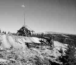
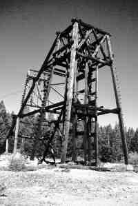
Along the way, there are interpretive areas, including old mine dumps, plugged mine shafts, towering headframes, and the remains of 19th century cabins and other mine-related structures. West of Colorado Mountain College and east of the airfield are several fixed, mounted viewing scopes, each labeled with the name of the peak visible through its sights.
Those lacking the time or energy to complete the entire Mineral Belt Trail can access portions of it from a half-dozen different trailheads.
Highlights of the July 29 Grand Opening ceremonies will include the unveiling of a huge boulder hauled from the Climax molybdenum mine site and bearing the names of major Mineral Belt Trail contributors. These include: ASARCO; Union Pacific Railroad; Conlin Associates; GOCO (Colorado State Parks); Lake County; the City of Leadville; Colorado Mountain College; Leadville Coalition; the Greater Leadville Area Chamber of Commerce; the U.S. Forest Service; the Colorado Department of Transportation; and the Environmental Protection Agency.
Individuals affiliated with these organ izations and private property owners who granted easements necessary for trail construction will also be honored.
Work will continue into next summer to complete rest stops, install benches and additional viewing scopes, and replant certain escarpments. Meanwhile, the Mineral Belt Trail is already gaining a reputation as one of Colorado’s finest non-motorized trails. For proof, just walk, jog, bicycle (or in a few months, cross-country ski) this new trail, and see for yourself.
Lynda La Rocca lives near Leadville, and looks forward to using the trail when she’s not writing, teaching, or answering bizarre questions posed by the tourists who appear uninvited on her doorstep.