By Phillip Benningfield
Most of us, if fairly avid outdoors folks, have strolled along the Colorado Trail, the Continental Divide Trail and the easy-to-get-to trails surrounding our little mountain towns. What we miss by taking the well-trodden routes – although these aforementioned trails are superb – is the personal gratification we find when our minds are fulfilled. We feel the need to see what is around the next ridge, what is over the next pass, what sublime view we might otherwise miss. The selections here are certainly known by the more adventurous who can’t get enough of Colorado’s fine offerings. If you have not seen the rock formations in and around La Garita or even further along the off-the-beaten path, then pack a lunch and dinner, take plenty of water and do not plan on getting home on time. A detailed road atlas and/or gazetteer will show all the necessary roads.
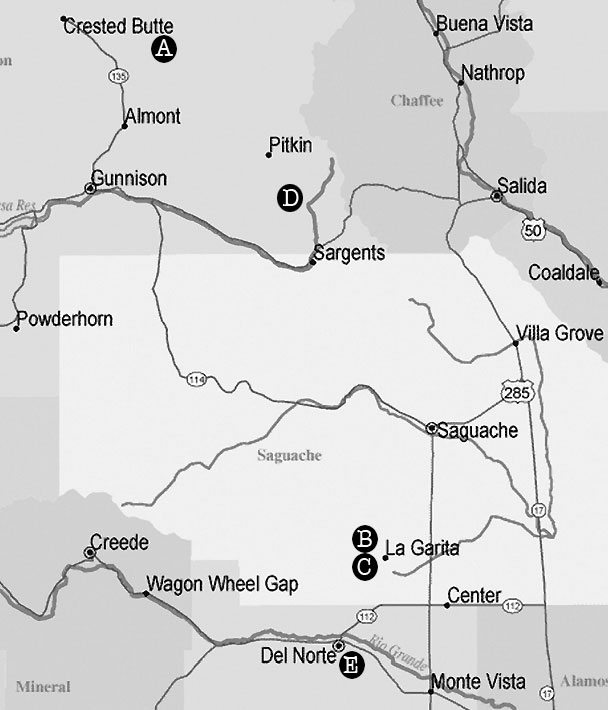
Cement Creek Pass (A)
Reached from the heavily traveled Taylor River Road FR742 (simply drive northwest from the reservoir to road’s end), this short hike on a singletrack sees copious amounts of motorized travel, but is quiet during the week. From the intersection of Cottonwood Pass Road and Taylor River Road head north approximately 20 miles on a fine dirt road to the trailhead for Cement Creek Pass. You will be on the opposite side of the pass from Crested Butte South and Cement Creek Road. The hike strolls above the headwaters of the Taylor River in Eyre Basin. Total time, with many stops to check out flowers and views, takes less than two hours to reach the pass. The area offers many camping spots and a quieter zone than the more frequented Crested Butte trails.
 Rock Garden near Penitente Canyon (B)
Located a couple of west miles from La Garita (six miles west off US 285 between Saguache and Center on G Road) on 41G Road. The canyon has parking for a few cars and is across the road from a big red shed and ranch. The Rock Garden is a very mellow hike below cliffs used exclusively for the pursuit of hard sport climbing and bouldering. The cliffs are an array of fluorescent lichen and striped volcanic tuff. The best thing about hiking around the Rock Garden is that the canyon sees far less traffic than the nearby Penitente Canyon: a canyon not to be missed as well with the unbelievable mural of the Virgin of Guadalupe. If you need a longer stroll, the myriad trail systems stretch well beyond Penitente Canyon to Witches Canyon and past Sidewinder Canyon to the south
La Ventana Arch between La Garita and Del Norte (C)
As obscure as outings get, the La Ventana arch is a seldom-visited Colorado landmark. Reached off the back road (FR660) between La Garita (7.5 miles) and Del Norte (9.5 miles), the arch is well worth the journey and can be done the same day as hiking in the Rock Garden. The sizeable arch, around a 100 feet tall, is seen from Forest Road 659 and can be hiked to within a half hour. Signage off of 38 Road (south from La Garita) points the way and takes you into an area littered with rock formations and piñon/juniper forest. For mountain bikers this area is part of the Great Divide Mountain Bike Route and makes for a great rolling ride.
Canyon Creek Trail #481 (Whitepine) (D)
A trail made better known by the Vapor Trail 125 mountain bike races, is superb for a day hike as well. It is located directly across from Snowstake campground on Forest Road 888 near Whitepine (on the west side of Monarch Pass). The road is just east of Sargeants and is well marked. The hike or bike begins with a couple of steep switchbacks to reach the serpentine trail along Canyon Creek. I have not seen big wildlife or loud people, but enjoyed the peaceful immersion in an obscure riparian zone. As with so many trails in Gunnison County, motorcycles and equestrians may be encountered, so choose your time mid-week.
West San Francisco Creek (Del Norte) (E)
Just south of Del Norte on Forest Road 13, this trail, recently upgraded by the Southwest Conservation Corps, sees little use besides horses and the occasional hiker or biker. For the more adventurous (an all-day hike) the trail leads all the way to Bennett Peak. An earned reward of the absolutely jaw-dropping San Francisco Lakes can be absorbed below Bennett Peak’s northeast-facing cliffs. For added heart-pounding, continue around the north expanse of Bennett to a maintained ATV road and the eventual connector with Burro Creek (a shuttle experience, overnighter or really long run).
Phillip Benningfield struggles as a writer and barista and likes the faraway places.