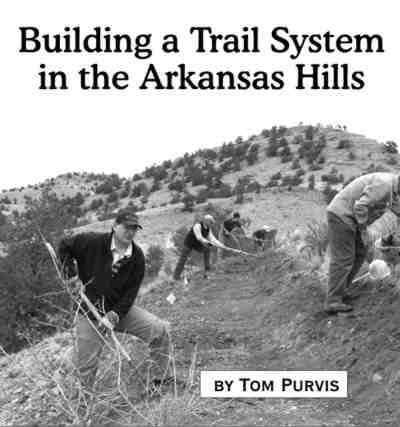
Article by Tom Purvis
Recreation – January 2009 – Colorado Central Magazine
THERE ARE TRAILS all over. Deer, elk and cows all make trails that go to watering holes, grassy areas and safe cover. If there’s a good spot for fishing, a pretty waterfall or a place up high with a good view there will usually be a trail leading there. If there’s a relatively easy way to get up a mountainside or into a canyon, a trail will usually follow that route. Some trails are planned and constructed, and some trails just happen.
Here in the arid west it doesn’t take very much traffic to make a trail. People usually walk on trails when there isn’t a road available because trails are the easiest way for them to get where they’re going. Some people take to the trails because they are looking for a workout so they’ll find a steep path, or create one by walking up a steep slope a few times.

A problem with steep trails is that they promote erosion. Running water will follow the trail down. A little water will run near the top and more towards the bottom.
Any trail is a disruption to the stability of soils, since it denudes vegetation and disturbs compaction. A trail that travels in a direction at or near the fall line (the steepest, most direct path up and down the hill) is not sustainable because water runs down the trail bed, washing away the unstable soil. As the finer soil in the trail is eroded away, the trail bed becomes deeper and fills up with rocks too large to be washed away. At some point trail users begin to walk around the worst parts of the trail which causes a wider area of vegetation to be denuded and more compacted soil to be loosened. The trail becomes wider and deeper until it is a useless and ugly gully. By then all the fine soil and sand that used to be in the gully has traveled downhill, often finding its way into streams and rivers.
Trails that just happen often suffer from poor design. Right near Salida there are lots of trails, and Salidans like to use them. The problem is that most of them just happened and many suffer from poor design. A lot of the trails people liked at one time have become ugly gullies full of rocks.
A group called Salida Mountain Trails has been working to provide more trails in our area. Our mission is to create trails that are sustainable, so that they will be an asset for a long time. By designing and routing carefully, we work to satisfy the demand for trails in a way that does not promote erosion.
We have adopted a trail design and construction standard based on concepts developed by the International Mountain Bicycling Association (IMBA). The goal for using these standards is to reduce the erosive impact of trails.
There are many rules and guidelines in the IMBA standards, but the core concepts are actually quite simple. Water follows the steepest line down hill, and only diverts from that line if it finds a channel to follow. By keeping trail grade at less than half of the side slope grade, and by slanting the trail bed in the same direction as the slope, the trail does not become an attractive channel. Water is encouraged to sheet across the trail rather than turning off the fall line and running down the trail bed. If the trail’s grade periodically reverses and if there are dips in the grade, water soon reaches a place where it will naturally drain off even if it does begin running down the trail.
PEOPLE LIKE TRAILS that go somewhere, and they like options. Some people want to walk for 20 minutes on a nice wide trail; others want to run 8 miles, leaving from town on one trail and looping back on anther. Some want to ride mountain bikes.
Salida Mountain Trails wants to do more than build some good trails that don’t erode the hillside; we want to create a system of trails. Our plan is based on a Stacked Loop design. The trails closest to the trailhead (the bottom of the stack) are wide and not so steep. They connect to optional trails that become steeper, narrower, and longer. The farther a trail user travels from the trailhead, the more challenging the trails become.
Our primary area of focus is the creation of a stacked loop trail system across the river from downtown Salida. We are calling it the Arkansas Hills Trail System. We recently completed a trail section that is on City of Salida property. It starts at the Spiral Drive Gate. It is wide and has an easy grade. A trail user can walk or ride a bike on this trail and make a loop back to the start by using the lowest circle of Spiral Drive as it winds around Tenderfoot Hill. That trail, known as ‘Lil Rattler, is an example of the kind of trail that will exist at the bottom of the stack.
The keystone of our plan for the Arkansas Hills side is a trail to be called The Backbone. When completed, this trail will be ten or more miles long. It will go from CR175 (Ute Trail) near Piñon Hills to Sweetwater Gulch, nearly 2 miles southeast of Tenderfoot Hill as the crow flies. It will traverse the land contours, staying around 7,500 feet elevation for its entire length. It will be the second layer of the stack, and eventually it will connect to longer and more difficult trails that travel back into the higher and more remote parts of the BLM parcel northeast of Salida (the 3rd layer of the stack).
Work on The Backbone has begun, and as of the writing of this article, almost half a mile of new trail has been built on BLM land near Tenderfoot Hill.
Our plan includes signs and maps. We hope to have a very open and understandable system, so that residents and visitors alike can enjoy the trails without becoming lost or disoriented. Our plan is patterned after trail systems near Durango, Cortez, Winter Park, Fruita and Grand Junction where there are very good signs, maps and information kiosks. We also hope to incorporate local culture and history as Leadville does with the Mineral Belt Trail and Buena Vista does with the Midland Grade. We plan to make available information about Salida’s railroad and mining heritage.
THE TRAILS THAT PEOPLE USE, particularly the ones across the river from downtown Salida, are not all on public land. Much of the work we are doing is in partnership with the Bureau of Land Management. SMT planners refer to our local BLM land as “the soap ring.” As you climb out of the valley floor beyond the city, there tends to be a layer of private land, then the BLM soap ring, then San Isabel National Forest.
The soap ring usually starts at a few hundred feet above the valley floor, at around 7,250 ft. It tends to be rugged land, arid piñon/juniper with some scattered ponderosa pine and Cottonwood, drained by sandy washes. No perennial streams flow out of the current planning area. The upper boundaries of the BLM are usually between 8,250 and 8,750 ft. elevation. We also have plans for a Methodist Mountain Trail System to the south of Salida.
When we develop trail systems to be built on BLM land, we have to make the planned routes specifically known so that a National Environmental Policy Act (NEPA) analysis can be performed. The areas to be impacted by trails must be studied for the existence of archæological artifacts, rare or endangered plant and animal species, critical wildlife habitat, etc.
Many of Salida’s currently existing trails are on private land, at least on the Arkansas Hills side. The City of Salida owns a fairly large parcel around Tenderfoot Hill. The Union Pacific Railroad (UPRR) owns quite a bit of land beyond the railroad right-of-way. There are several parcels of agricultural land owned by cattle companies between the UPRR right-of-way and the BLM boundary. Many of the trails that currently exist cross from one landowner to another without any regard for boundaries.
For trails to be officially recognized by the BLM they need to be approved by the adjoining land owner or land manager. Our trail system plans are often driven by the need to respect the rights and wishes of private land owners. On the Arkansas Hills side of Salida, there are exactly three public places to access the “soap ring.” One is from CR175 (Ute Trail) just above Pinon Hills, one is from CR177 (the jeep road behind Calco) east of downtown, and one is from Spiral Drive via city-owned land adjoining BLM. The easiest to reach and therefore the most strategically important is the city-owned land around Tenderfoot Hill.
The City of Salida has been very supportive of our efforts. They have allowed us to build two trail segments: ‘Lil Rattler and Tenderfoot Trail, which leaves Spiral Drive from the southeast side of tenderfoot and traverses back to near the boundary with BLM land. Thanks to the city’s support, we plan to have a very convenient entry to the Arkansas Hills Trail System right across the river from downtown.
WHAT ABOUT THE RAILROAD? As of the writing of this article, the sole legal way to access Spiral Drive and Tenderfoot Hill is to cross the river on CR175 at Sand’s Lake and then turn right on CR176 after crossing the tracks. The service road along the tracks on the Hollywood side is called Railroad Boulevard. It is a private road. Only UPRR vehicles and traffic destined for Calco can travel legally on that road. Others are trespassing on Union Pacific land. Crossing the Arkansas River using the F Street Bridge, then crossing the UPRR tracks is also an illegal trespass.
Salida Mountain Trails, the Arkansas River Trust, and Salida Parks, Open Space and Trails (SPOT) are currently working with the UPRR to establish legal below-grade crossings utilizing wash underpasses, such as the one that bridges the Cottonwood Gulch wash a quarter mile southeast of the F Street Bridge. The railroad may become active again one day, which would expose trail users to citations for trespass. Even if that does not happen SMT wants to establish a legal crossing in the interest of better relations with the UPRR.
This route across the tracks will connect to the jeep road that crosses behind the Calco plant, which is a public right-of-way, CR177. The CR177 right-of-way starts by the water tank on Spiral Drive, goes down past the city’s burn pile, then passes directly in front of Hollywood. CR177 continues behind Calco and beyond, southeast all the way down to the underpass downstream from the stock sale barn.
BLM’s boundary comes very close to CR177 down near the wastewater treatment facility, so we plan to have an access trailhead in that area. Also on Ute Trail just above Pinon Hills there will be access to our trail system, since the road passes directly through BLM land in that area. Those access points will form the two end points of The Backbone which was mentioned previously.
Who will use these trails, and how will they happily coexist? The trail systems that we are building are planned for non-motorized users. We have people in our group who ride motorcycles off-road, and we don’t have any prejudice against motorized travel on public land. But we feel that the trails that are right near town should be non-motorized for the safety and enjoyment of the human-powered community, because it’s far easier for the motorized folks to get farther up and out of town.
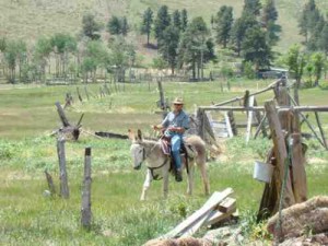
What about horse-powered usage? We don’t see many horseback riders out there. We see a few over on the Methodist Mountain side of town, but rarely are there any in the Tenderfoot area of the Arkansas Hills. There are a wide variety of trails available to equestrians in Chaffee County, and their outings often start with a truck and trailer ride out to more remote locations farther from town.
Our target users are the various flavors of pedestrian travel and mountain bikers. Our hope is that all the trail users will coexist happily.
THE FACT THAT SMT has adopted a mountain bicycling organization’s standards for trail design is not a coincidence. SMT was founded by mountain bikers, and the perspective of mountain bikers is a strong influence on our plans and guiding principles. But it is important to know that we seek to represent all non-motorized trail users, and we do have representatives of non-biking trail user groups in our core group.
The fact is, trail quality is absolutely key to mountain biking. When trails are steep, rutted and rocky other trail users can still use them. A mountain biker can only realistically travel one way, downhill, on a very steep or loose trail. And at some point of steepness and ruggedness, only an expert mountain biker can ride on it at all. Our sport is not really possible without reasonably well-designed trails.
Good trails also promote good relations between trail users. A mountain biker, traveling downhill on a steep, rocky trail is working hard to control speed and stay in control. When that mountain biker meets a pedestrian on such a trail it is much more likely that the hiker will be startled or even frightened by the biker.
Well designed, sustainable trails can be more enjoyable because less energy is spent focusing on where to step, what rock to avoid, how to maintain traction, and so on. The trail user is more free to look around and enjoy the surroundings. The trail itself can be quite attractive, blending into the land rather than appearing as a scar. It can follow land features, weaving through trees and boulders, curving into gullies and around outcroppings.
Trail user harmony is also enhanced when there are plenty of trails. There is clearly a high demand for trail miles in the Salida area. There are people out using those trails every day, especially in the chillier months. The greater the density of users, the more encounters. The more encounters, the more chance for conflicts. As SMT works to meet the demand for new trails, we will introduce some trails that are more popular for mountain bikers, some that are more popular for hikers and dog-walkers, and some that are more popular for trail runners. There will be more options and more miles of trail per user. There will always be steep and rutted trails — making them disappear will never be practical, and there are trail users who prefer them. As long as people are using the old steep, rocky trails, they will exist, even if attempts are made to cover them over and re-vegetate.
[Trail system map.]
Residents of Salida have made it known through the recreation survey conducted by Salida’s Recreation Department that trails are one of their most valued amenities. Clearly, our current trails get used and more trails will be better. But Salida also relies heavily on visitor dollars. The trails that we are going to build will prop up the dreaded shoulder season. More people will come here in October, November, December, March, April, and May. The trails will also help attract new residents who will add money to the local economy and tax base.
There is a high demand for trails. And as SMT recognized years ago, there will be new trails built to supply that demand. Those new trails can be good, sustainable trails or they can be bad trails. Bad trails become an eyesore, and they are bad for the health of the Arkansas River. We have a very strong trout fishery in the river now. Satisfying demand for trails in a sustainable, responsible way will do more to protect that resource.
How can you help? Salida Mountain Trails is a chapter of the Arkansas River Trust. Our association with the Arkansas River Trust gives us 501(c)3 status, so contributions are tax deductible.
We have periodic volunteer days, and a large supply of trail-building tools. Watch your local media outlet for information about when the next volunteer day is happening. Or contact us at: link.
Tom Purvis lives in Salida and helps build the trails he uses.