by Kenneth Jessen
In its younger days, Colorado had two types of forts. The earliest ones were developed during the fur trade era up until the mid-1800s. Both Native Americans and fur trappers would bring in pelts to trade for any number of items. As settlers arrived and stage routes were established, regional Indian tribes started to resent having their land taken away piece by piece. Some Natives attacked settlements, raided stage stations and disrupted travel over these established routes. The second type of fort was established by the government, namely military forts.
In 1803, the United States negotiated with France for the Louisiana Purchase, but its extent was unknown. Presumably it included all of the rivers that drained into the Mississippi, along with the Red River. Some early maps showed its headwaters in the Rocky Mountains, but in reality, the Red River starts in the panhandle of Texas. In 1806, Lieutenant Zebulon Pike led an expedition into what would eventually become the southern part of Colorado, but at the time, it was Spanish Territory. Pike, seeking to find the headwaters of the Red River, made a number of blunders. First he thought it was the Arkansas River; then, seeing the Rio Grande, he thought it was the Red River. Some historians, however, speculate that his real mission was to determine the military strength of the Spanish army. The expedition consisted of a volunteer doctor plus 22 men, including two lieutenants, a sergeant and a couple of corporals.
The Pike Stockade
As he progressed south through the San Luis Valley, Pike elected to construct a stockade near the Conejos River in February 1807. Several men, who had received frostbite in crossing the mountains, were transported to the stockade to recover. Also, the fortress-like stockade was to ward off a potential attack by Natives or by the Spanish should Pike be discovered.
The log stockade was 36 feet square with walls 12 feet high. To maximize its defensive nature, entry required crawling over a plank through a small hole below the lower course of logs. Fastened to the inside of the walls were platforms to allow soldiers to shoot through holes located about eight feet above the ground. Although unimpressive, the stockade was the first building set up by Americans in Spanish territory, and it was the first time an American flag was flown in what would become the state of Colorado.
During a hunting trip to supply meat for the stockade, the discharge of a rifle by Pike alerted a Spaniard and his Native scout. As the Spaniard approached Pike, the lieutenant played dumb and explained that he was simply out hunting. His story did not make sense and although it is hard to understand, Pike invited the two of them into the stockade. The Spaniard reported back to his commander, and it wasn’t long before the stockade was surrounded by soldiers. Pike invited the two lieutenants into his stockade for breakfast and stuck to his story about the Red River. Acting surprised, Pike struck the American flag when told he was in Spanish territory. Pike and his men were captured and taken first to Santa Fe, then to Chihuahua, Mexico. They were released in July 1807.
The stockade was abandoned and rotted away; however, Pike had taken good notes as to its size and location. In 1926, the state of Colorado purchased the land, and in 1952, the stockade was reconstructed by History Colorado (formally the Colorado Historical Society). It is a National Historic Landmark.
The Pike Stockade is located 15 miles southeast of Alamosa near the intersection of County Roads Y and 24. The nearest town is Sanford. To reach the stockade, travel south on 24, then follow the road east to its end. The entrance is marked by a sign. The area has parking, restrooms and a picnic shelter, plus the reconstructed stockade. Dense vegetation and standing water surround the stockade. It is a pleasant location for a picnic, provided adequate mosquito repellent is kept handy.
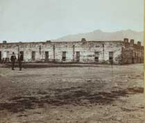
 Bent’s Old Fort
William Bent, with brothers Charles, Robert and George, along with Ceran St. Vrain, saw the need for fur trading posts. Their first attempt was a small post halfway between modern-day Pueblo and the foothills. This led to a more ambitious project farther down the Arkansas River to service the ever-growing traffic along the Santa Fe Trail. Relative to today’s towns, the location was east of La Junta on the north side of the Arkansas River. At the time, the river marked the border between the United States and what was once Spain and now Mexico.
Construction of what turned out to be a large fort took four years, with its opening in 1832-1833. Initially, it was called Fort William and was soon changed to Bent’s Fort or Fort Bent. Trappers and Natives came to trade their furs for supplies. At times, an estimated thousand or more were camped in the nearby cottonwoods along the north bank of the river. One writer generalized that the fort was a rendezvous for virtually every type of humanity.
Among the many items kept in stock were guns, lead to mold bullets, black powder, cooking utensils, kettles, tobacco, coffee, sugar, cured meat, flour, traps and blankets. Bent’s Fort had a monopoly by virtue of being the only settlement, supply point or trading post for hundreds of miles in a vast, unpopulated land.
In the late 1840s, the fur trade was tapering off as demand for beaver pelts fell. William Bent had risen to become the fort’s primary owner. In 1849, he wanted to sell his fort to the U.S. government and move his business farther downstream. He was offered less than what he thought it was worth. Frustrated by the dealings, Bent removed the items of value from his fort.
One account has Bent setting his fort on fire and watching the flames reach the powder magazine. The fort was presumably destroyed by the explosion that blew down its adobe walls. Other historical accounts, however, vary on this issue, especially as to the extent of the damage. In 1853, one traveler noted the crumbling adobe walls, but for the most part, the fort still stood. After 1859, travel along the Arkansas River surged, motivated by the discovery of gold to the west in the Colorado mountains. Travelers used the fort as a stopover. Stage travel along the Santa Fe Trail enhanced the use of Bent’s Old Fort and by 1861, it became a stage station with meals served to travelers. A post office opened two years later.
The final abandonment of Bent’s Old Fort was in 1873, and contemporary archeologists speculate that some of the adobe bricks may have been carried off by homesteaders desperate for building materials. The Arkansas River flooded in 1921, eradicating much of what was left, and during the Dust Bowl of the 1930s, the site was partially buried by blowing sand.
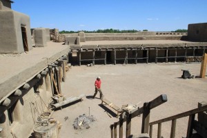
The La Junta Chapter of the Daughters of the American Revolution marked the site of Bent’s Old Fort in 1912 and took official ownership in 1926. Jumping ahead, archeologists re-established the fort’s exact location. Artifacts were collected and work started in May 1975 to rebuild the structure. The reconstructed Bent’s Old Fort was dedicated the following year, and it is administered by the National Park Service.
[InContentAdTwo]
Today, parking is kept at a respectable distance so that visitors can view the fort without the visual intrusion of automobiles. Enough acreage was purchased around the fort so that visitors get a feel for the fort’s isolation and surroundings. A good foot path provides access to the banks of the river, and one can only imagine the Indians camped in the cottonwood trees.
The fort is a fun place to visit for families. There are many activities that recreate a typical day in the life of a fur trading fort. The sound of splitting wood and the ring of a blacksmith’s hammer on an anvil are typical. There are also guided tours and special events.
To reach Bent’s Old Fort, use Colorado 194 east from La Junta. It is only six miles to the entrance. Parking is close to the highway and visitors can walk or ride a complimentary shuttle to the fort.
Fort Massachusetts and Fort Garland
The first military fort in the San Luis Valley was Fort Massachusetts, located on the south-facing slope of Blanca Peak along Ute Creek. Built in 1852, its purpose was to protect settlers in the San Luis Valley, but it was not centrally located and worse yet, it was vulnerable to attack. Its location may seem strange today, but when the site was selected by Major George Blake, it was north of the Sangre de Cristo Grant on open land.
After just six years, Fort Massachusetts was abandoned in favor of Fort Garland. This new fort was located a half-dozen miles farther south and down on the valley floor. A 25-year lease was signed with the Sangre de Cristo Grant. There were a number of pivotal events over the years at Fort Garland. Colorado Volunteers trained there and in 1862 marched south to Glorieta Pass, New Mexico. Here they met and defeated the Confederate army.
Possibly the best-known commander of Fort Garland was Christopher “Kit” Carson. Many books and articles have been published about Carson’s colorful career as a trapper, trader and hunter. Explorer John C. Fremont hired Carson as a guide and during the Mexican War, Carson became an Indian agent and was appointed to the rank of colonel. In 1866, Carson took command of Fort Garland. He negotiated with Chief Ouray, resulting in the removal of the Ute Indians to a reservation. Carson died two years later at Fort Lyon.
After the arrival of the Denver & Rio Grande over La Veta Pass in 1877, the need for Fort Garland was greatly diminished. The fort was closed as a military establishment six years later. The grounds became part of the Trinchera Estate, and the fort itself became a commercial property, with Kit Carson’s son running the general store.
William Meyer purchased the aging adobe fort and made the commandant’s quarters his home. Ownership passed on with plans to raze what structures remained and to sell any useful materials. Concerned citizens formed an association and sold $5 shares to save the fort. The association eventually purchased the property, and in 1945, History Colorado (formerly the Colorado Historical Society) took ownership. The long process of rehabilitating the five remaining buildings out of the original 22 started, and in 1950, Fort Garland was opened to the public.
It is an educational joy to visit Fort Garland with each of the rooms surrounding the parade grounds containing furniture and equipment that reflects the room’s original function. As visitors move in and out of the rooms, informative signs relate to them the fort’s history. Detailed dioramas show scenes that typify the era. The fort has an excellent book store with many publications specific to the San Luis Valley.
Fort Garland is located at the western base of North La Veta Pass and just a quarter-mile south of U.S. 160 on Colorado 159 in the town of Fort Garland.
Francisco Fort
In 1862, Colonel John M. Francisco was the sutler at Fort Garland and ventured over one of several passes into the Cuchara Valley. Upon reaching the valley he declared, “I have found my home. This is paradise enough for me.” He and his business partner, Henry Daigre, purchased 48,000 acres of the vast Vigil land grant. They hired 20 men to construct a fort with two-foot-thick adobe walls approximately 100 by 100 feet. Its interior rooms faced into a central plaza. The fort had an excellent well. There was far too much land for these men to develop so they leased acreage to ranchers and farmers, with the fort acting as the center of commerce. In 1871, under the name Spanish Peak, a post office was set up within its walls.
The fort was attacked in 1863 by a band of Utes. The men in the fort were rallied to gun ports along the parapets on top of the flat-roofed buildings. One man volunteered to ride to Fort Lyon and get help. By the time the cavalry arrived, the Natives had decided to retreat.
The arrival of the narrow gauge Denver & Rio Grande in 1876 changed the economy of the area and brought in a wave of new settlers. The tracks advanced the following year over La Veta Pass at 9,390 feet and at the time, it was the highest railroad pass in the United States. Around Francisco Fort, the railroad platted the town of La Veta and constructed a depot just two blocks north of the fort. The name of the post office was changed to La Veta, and the adobe walls on the east and north sides were taken down to allow the fort to be developed into a commercial plaza.
Francisco Fort is located at 306 South Main St. (Colorado Hwy. 12). It is operated by the Huerfano Historical Society and has an excellent book store with hard-to-find area history.
Ken Jessen lives in Loveland and is always on the lookout for old ghost towns that might predate his advanced age.