By Tyler Grimes
Up the East Gulch from its confluence with the Arkansas River, a few miles east of Texas Creek in Fremont County, is Echo Canyon. Further up the gulch, Table Mountain looms to the southwest, past Bull Ridge.
Surrounding this mountain, gulch and canyon are 32,000 acres of roadless Bureau of Land Management (BLM) land. The area is classified under the BLM’s Area of Critical Environment Concern (ACEC) because of its valued species: a BLM Instant Study Area protecting 17 native grasses: and its importance as a wildlife corridor for mountain lion, Rocky Mountain bighorn sheep, black bear, elk, mule deer, pronghorn, Gunnison prairie dog, wild turkey, peregrine falcon, Mexican spotted owl, great blue heron and bald eagle. Conservation Science Partners (CSP) recognizes 7,641 acres of Table Mountain as having “important ecologically based indicators of high biodiversity, resilience to climate change, and landscape connectivity.” The unit is deemed one of Central Colorado Wilderness Coalition’s (CCWC) top 11 areas worthy of wilderness designation.
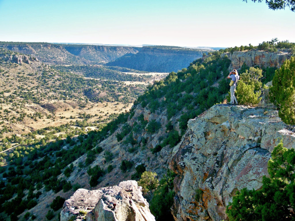
Table Mountain/Echo Canyon is one of many areas that could fall under Lands with Wilderness Characteristics (LWC) when the BLM’s Resource Management Plan (RMP) begins its revision process this coming year. A 60-day public comment period will begin this June upon the BLM’s Royal Gorge Field Office’s Notice of Intent being published in the National Register. “Public comment is really important because Resource Management Plans are in effect for 20 years,” said Kyle Sullivan, public affairs specialist at the Royal Gorge Field Office. “We really look forward to public comment.” LWCs dictate management, but they are not a special designation like a Wilderness Study Area or an ACEC. The RMP will affect the management of all uses on BLM land, such as “energy development, livestock grazing, recreation and timber harvesting,” according to the BLM website.
Wilderness characteristics are defined in The Federal Land Policy and Management Act of 1976 by sufficient size, naturalness, and outstanding opportunities for either solitude or primitive and confined recreation. To be an LWC, land must have at least 5,000 acres uninterrupted by roads. Naturalness is defined in the Act: “The area must appear to have been affected primarily by the forces of nature, with the imprint of man’s work substantially unnoticeable.”
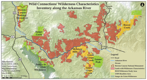
The Federal Land Policy Act of 1976 directs the BLM to maintain an inventory of lands that possess wilderness characteristics. The Royal Gorge Field Office manages 680,000 acres of public land; and it inventoried 257,325 acres in 2013 and found 77,765 acres with wilderness characteristics. However, citizen groups also conduct inventories outside of the BLM, which can be used to influence the RMP. One citizen organization, Wild Connections, worked with volunteers to inventory approximately 290,000 acres and is proposing 250,000 acres over 24 areas to be managed as LWC. “Discrepancies are not uncommon (between BLM inventories and citizen inventories),” said Kalem Lenard, outdoor recreation planner for the Royal Gorge Field Office. “If a group wants to present their findings to the BLM, they can, and if they came to a different conclusion then we’ll go look and make a determination.”
Wild Connections
Wild Connections began 20 years ago as a small group of volunteers mapping roadless areas for the U.S. Forest Service (USFS). Founder and board member emeritus Jean Smith said the organization “formed in response to two trends in public lands management. First, the emerging science of conservation biology gave credibility that the best strategy to protect native species and their habitat was to preserve large roadless areas as protected cores.” These corridors allow for wildlife migration, protect biodiversity and increase the ability of the land and its inhabitants “to respond to changes in habitat or climate … Second, conservation groups were convinced that the USFS (Roadless Area Review and Evaluation) inventory did not include the real geographical context of roadless area.” At the time there was no other group in the Pike-San Isabel National Forest organizing volunteers to inventory and gather hard data that would convince the Forest Service to eventually alter the boundaries of roadless areas to conform to the real situation on the ground.
By 2001 all of the roadless areas on the Pike-San Isabel were mapped, so from 2002-06, Wild Connections focused its efforts on the “Wild Connections Conservation Plan.” The document was based on roadless core reserves and served as a forest-wide management recommendation and as place-based specific management. The plan is a regional ecosystem strategy that forges a link in an unbroken chain of North American wildlands.
Since it began, Wild Connections, with the help of volunteers, has mapped 120 roadless areas on public lands. With help from Wild Connections research, the Pike-San Isabel added 104,700 acres to its roadless inventory in the Colorado Roadless Rule. They have also inventoried 250,000 acres of BLM and hope their reports will help place more of that land under LWC. Wild Connections has one staff person, John Sztukowski, wildlands conservation coordinator.
Based in Salida, Sztukowski has worked on BLM inventories and on condensing those findings into a 700-page report to be presented to the Royal Gorge Field Office. “We try to be as objective and environmentally sound as possible, to line up with the BLM manual (6310),” he said of the inventory reports. Sztukowski also leads hikes to areas found within the report and will be hosting more events during the summer months.
[InContentAdTwo]
Sztukowski will also be working with other coalition groups as the RMP public comment period nears – organizations like The Wilderness Society, Conservation Colorado, Quiet Use Coalition, Great Old Broads for Wilderness, Colorado Wildlife Coalition, Central Colorado Wilderness Coalition, and Rocky Mountain Wild, to name a few. “We want to bring more folks to the table, because this process is just starting,” said Sztukowski.
The public comment period, referred to as the “scoping phase,” is a 60-day period following the announcement of the Resource Management Plan. The Royal Gorge Field Office is one of over 30 BLM regional offices in the process of updating their RMP. That will be the most crucial time for the public to be involved before the yearlong “drafting phase.” Wild Connections will be working particularly hard to change the BLM’s mind on a few areas.
“Echo Canyon and Table Mountain are one area we’re going to bat for the most,” said Sztukowski. “The area is our highest priority LWC given its vast size and many values. Like all of the LWC areas we’re proposing, it aligns with BLM’s multiple-use and sustainable yield policy, protecting a host of important resources, including rich biodiversity, wildlife corridors, and natural and scenic landscapes, as well as outstanding recreational opportunities such as hunting, fishing and hiking.”
Standing on Bull Ridge, the Sangre de Cristo Range extends to the south, rising out of the valley. Below and west is the rugged Echo Canyon, and opposite, the flat-top mesa and highest point visible, Table Mountain. Through informal observation, the characteristics of the landscape appear to resemble that of wilderness.
For more information on Wild Connections, visit their website at WildConnections.org, or email John@wildconnections.org.
Tyler Grimes is looking forward to joining some of Wild Connections’ hikes this summer.